Galmaarden geodata
Galmaarden (Flanders) is a populated place; located in Belgium in Europe/Brussels (GMT+2) time zone. With population of 7,939 people, there are 369 cities with bigger population in this country. Compared to other cities in Belgium, 53.2% of cities are located further ↑North; 75.3% of cities are located further →East and 60.6% of cities have higher elevation than Galmaarden. Note1
Administrative division(s):
- Level 1: Flanders
- Level 2: Provincie Vlaams-Brabant
- Level 3: Arrondissement Halle-Vilvoorde
- Level 4: Galmaarden


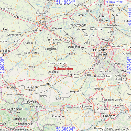
Galmaarden GPS coordinates[2]
50° 45' 14.004" North, 3° 58' 16.356" East
| Map corner | latitude | longitude |
|---|---|---|
| Upper-left | 51.19661°, | 3.26809° |
| Center: | 50.75389°, | 3.97121° |
| Lower-right: | 50.30694°, | 4.67434° |
| Map W x H: | 98.9×98.9 km | = 61.5×61.5mi |
| max Lat: | 51.46791° ⇑53.2% North |
| Galmaarden: | 50.75389° |
| min Lat: | ⇓46.8% South 49.53771° |
| min Long | Galmaarden | max Long |
| 2.59368° | 3.97121° | 6.25749° |
| W 24.7%⇐ | ⇒75.3% E |
Elevation
Elevation of Galmaarden is 32 m = 105 ft, and this is 67.5 m = 221 ft below average elevation for this country.
| Max E: |
582 m = 1909 ft | 60.6% |
| Avg. | 99.5 m = 326 ft | |
| Galmaarden | 32 m = 105 ft | |
Min E: |
1 m = 3 ft | 39.4% |
See also: Belgium elevation on elevation.city.
Geographical zone
Galmaarden is located in North temperate zone (between Tropic of Cancer and the Arctic Circle). Distance of this North polar circle is 1757.9 km =1092.3 mi to North.| Distance of | km | miles | from Galmaarden |
|---|---|---|---|
| North Pole | 4363.8 | 2711.5 | to North |
| Arctic Circle | 1757.9 | 1092.3 | to North |
| Tropic Cancer | 3037.4 | 1887.4 | to South |
| Equator | 5643.3 | 3506.6 | to South |


Nearby cities:
15 places around Galmaarden: (largest is in red/bold)
• Enghien
8.9 km =5.5 mi,  150°
150°
• Geraardsbergen
6.6 km =4.1 mi,  289°
289°
• Gooik
11 km =6.8 mi,  65°
65°
• Herne
5.6 km =3.5 mi,  126°
126°
• Herzele
15.8 km =9.8 mi,  338°
338°
• Ledeberg
13.1 km =8.1 mi,  40°
40°
• Lennik
14.8 km =9.2 mi, 65°
• Lessines
10.7 km =6.6 mi,  243°
243°
• Liedekerke
15.2 km =9.4 mi,  32°
32°
• Ninove
9.1 km =5.7 mi, 25°
• Pepingen
13.3 km =8.3 mi,  87°
87°
• Rebecq-Rognon
14.9 km =9.3 mi,  140°
140°
• Silly
12.2 km =7.6 mi,  195°
195°
• Sint-Maria-Lierde
11.5 km =7.1 mi,  308°
308°
• Sint-Martens-Lennik
15.4 km =9.6 mi, 65°
Sources, notices
• [Note1] Compared only with cities in Belgium existing in our database
• [Src1] Map data: © OpenStreetMap contributors (CC-BY-SA)
• [Src2] Other city data from geonames.org with taken over terms of usage.
• [Src3] Geographical zone / Annual Mean Temperature by Robert A. Rohde @ Wikipedia
