Bullange geodata
Bullange (Wallonia) is a populated place; located in Belgium in Europe/Brussels (GMT+2) time zone. With population of 5,340 people, there are 442 cities with bigger population in this country. Compared to other cities in Belgium, 83.6% of cities are located further ↑North; 100% of cities are located further ←West and 100% of cities have lower elevation than Bullange. Note1
Administrative division(s):
- Level 1: Wallonia
- Level 2: Province de Liège
- Level 3: Arrondissement de Verviers
- Level 4: Bullange


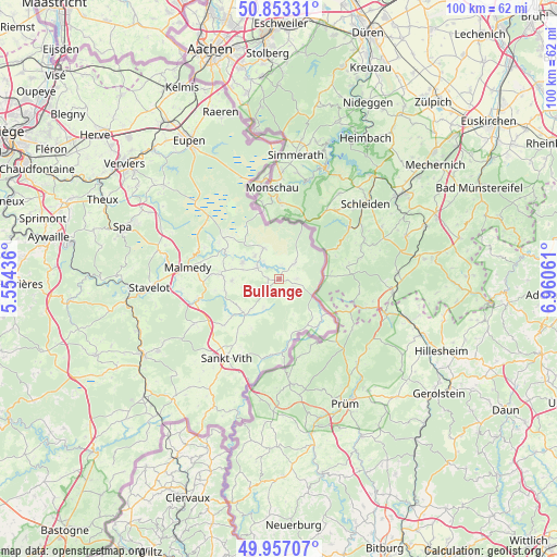
Bullange GPS coordinates[2]
50° 24' 26.316" North, 6° 15' 26.964" East
| Map corner | latitude | longitude |
|---|---|---|
| Upper-left | 50.85331°, | 5.55436° |
| Center: | 50.40731°, | 6.25749° |
| Lower-right: | 49.95707°, | 6.96061° |
| Map W x H: | 99.7×99.7 km | = 62×62mi |
| max Lat: | 51.46791° ⇑83.6% North |
| Bullange: | 50.40731° |
| min Lat: | ⇓16.4% South 49.53771° |
| min Long | Bullange | max Long |
| 2.59368° | 6.25749° | 6.25749° |
| W 100%⇐ | ⇒0% E |
Elevation
Elevation of Bullange is 582 m = 1909 ft, and this is 482.5 m = 1583 ft above average elevation for this country.
| Max E: |
582 m = 1909 ft | 0% |
| Bullange | 582 m 1909 ft | |
| Avg. | 99.5 m = 326 ft | |
Min E: |
1 m = 3 ft | 100% |
See also: Belgium elevation on elevation.city.
Geographical zone
Bullange is located in North temperate zone (between Tropic of Cancer and the Arctic Circle). Distance of this North polar circle is 1796.4 km =1116.2 mi to North.| Distance of | km | miles | from Bullange |
|---|---|---|---|
| North Pole | 4402.3 | 2735.5 | to North |
| Arctic Circle | 1796.4 | 1116.2 | to North |
| Tropic Cancer | 2998.8 | 1863.4 | to South |
| Equator | 5604.8 | 3482.7 | to South |


Nearby cities:
15 places around Bullange: (largest is in red/bold)
• Amblève
8.6 km =5.3 mi,  226°
226°
• Baelen
32 km =19.9 mi,  321°
321°
• Butgenbach
4.3 km =2.7 mi,  300°
300°
• Eupen
29.1 km =18.1 mi,  327°
327°
• Jalhay
26.5 km =16.5 mi,  309°
309°
• Limbourg
31.9 km =19.8 mi, 315°
• Malmédy
16.4 km =10.2 mi,  277°
277°
• Raeren
30.6 km =19 mi,  340°
340°
• Saint-Vith
16.8 km =10.4 mi,  213°
213°
• Spa
28.9 km =18 mi,  287°
287°
• Stavelot
23.2 km =14.4 mi,  266°
266°
• Stoumont
31.8 km =19.8 mi, 269°
• Trois-Ponts
27.7 km =17.2 mi,  261°
261°
• Vielsalm
27.9 km =17.3 mi,  240°
240°
• Waimes
10.3 km =6.4 mi, 274°
Sources, notices
• [Note1] Compared only with cities in Belgium existing in our database
• [Src1] Map data: © OpenStreetMap contributors (CC-BY-SA)
• [Src2] Other city data from geonames.org with taken over terms of usage.
• [Src3] Geographical zone / Annual Mean Temperature by Robert A. Rohde @ Wikipedia
