Baelen geodata
Baelen (Wallonia) is a populated place; located in Belgium in Europe/Brussels (GMT+2) time zone. With population of 3,928 people, there are 487 cities with bigger population in this country. Compared to other cities in Belgium, 65.3% of cities are located further ↑North; 98.2% of cities are located further ←West and 89% of cities have lower elevation than Baelen. Note1
Administrative division(s):
- Level 1: Wallonia
- Level 2: Province de Liège
- Level 3: Arrondissement de Verviers
- Level 4: Baelen


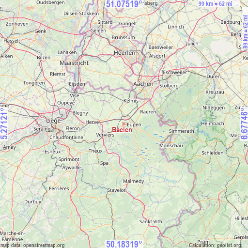
Baelen GPS coordinates[2]
50° 37' 52.716" North, 5° 58' 27.588" East
| Map corner | latitude | longitude |
|---|---|---|
| Upper-left | 51.07519°, | 5.27121° |
| Center: | 50.63131°, | 5.97433° |
| Lower-right: | 50.18319°, | 6.67746° |
| Map W x H: | 99.2×99.2 km | = 61.6×61.6mi |
| max Lat: | 51.46791° ⇑65.3% North |
| Baelen: | 50.63131° |
| min Lat: | ⇓34.7% South 49.53771° |
| min Long | Baelen | max Long |
| 2.59368° | 5.97433° | 6.25749° |
| W 98.2%⇐ | ⇒1.8% E |
Elevation
Elevation of Baelen is 257 m = 843 ft, and this is 157.5 m = 517 ft above average elevation for this country.
| Max E: |
582 m = 1909 ft | 11% |
| Baelen | 257 m 843 ft | |
| Avg. | 99.5 m = 326 ft | |
Min E: |
1 m = 3 ft | 89% |
See also: Belgium elevation on elevation.city.
Geographical zone
Baelen is located in North temperate zone (between Tropic of Cancer and the Arctic Circle). Distance of this North polar circle is 1771.5 km =1100.8 mi to North.| Distance of | km | miles | from Baelen |
|---|---|---|---|
| North Pole | 4377.4 | 2720 | to North |
| Arctic Circle | 1771.5 | 1100.8 | to North |
| Tropic Cancer | 3023.8 | 1878.9 | to South |
| Equator | 5629.7 | 3498.1 | to South |


Nearby cities:
15 places around Baelen: (largest is in red/bold)
• Aubel
11.3 km =7 mi,  313°
313°
• Dison
8.9 km =5.5 mi,  254°
254°
• Eupen
4.4 km =2.7 mi,  94°
94°
• Herve
12.8 km =8 mi,  274°
274°
• Jalhay
8.1 km =5 mi,  183°
183°
• La Calamine
10 km =6.2 mi,  15°
15°
• Limbourg
3.2 km =2 mi,  227°
227°
• Lontzen
6 km =3.7 mi, 22°
• Pepinster
13.6 km =8.5 mi,  241°
241°
• Plombières
11.8 km =7.3 mi,  354°
354°
• Raeren
10.7 km =6.6 mi,  68°
68°
• Sint-Pieters-Voeren
16 km =9.9 mi,  318°
318°
• Theux
15.8 km =9.8 mi, 226°
• Verviers
9.2 km =5.7 mi, 239°
• Welkenraedt
3.3 km =2.1 mi,  355°
355°
Sources, notices
• [Note1] Compared only with cities in Belgium existing in our database
• [Src1] Map data: © OpenStreetMap contributors (CC-BY-SA)
• [Src2] Other city data from geonames.org with taken over terms of usage.
• [Src3] Geographical zone / Annual Mean Temperature by Robert A. Rohde @ Wikipedia
