Leuven geodata
Leuven (Flanders) is a populated place; located in Belgium in Europe/Brussels (GMT+2) time zone. With population of 92,892 people, there are 7 cities with bigger population in this country. Compared to other cities in Belgium, 57.8% of cities are located further ↓South; 55.2% of cities are located further ←West and 63% of cities have higher elevation than Leuven. Note1
Administrative division(s):
- Level 1: Flanders
- Level 2: Provincie Vlaams-Brabant
- Level 3: Arrondissement Leuven
- Level 4: Leuven


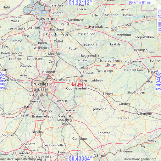
Leuven GPS coordinates[2]
50° 52' 46.524" North, 4° 42' 3.348" East
| Map corner | latitude | longitude |
|---|---|---|
| Upper-left | 51.32112°, | 3.9978° |
| Center: | 50.87959°, | 4.70093° |
| Lower-right: | 50.43384°, | 5.40405° |
| Map W x H: | 98.7×98.7 km | = 61.3×61.3mi |
| max Lat: | 51.46791° ⇑42.2% North |
| Leuven: | 50.87959° |
| min Lat: | ⇓57.8% South 49.53771° |
| min Long | Leuven | max Long |
| 2.59368° | 4.70093° | 6.25749° |
| W 55.2%⇐ | ⇒44.8% E |
Elevation
Elevation of Leuven is 28 m = 92 ft, and this is 71.5 m = 235 ft below average elevation for this country.
| Max E: |
582 m = 1909 ft | 63% |
| Avg. | 99.5 m = 326 ft | |
| Leuven | 28 m = 92 ft | |
Min E: |
1 m = 3 ft | 37% |
See also: Leuven elevation on elevation.city.
Geographical zone
Leuven is located in North temperate zone (between Tropic of Cancer and the Arctic Circle). Distance of this North polar circle is 1743.9 km =1083.6 mi to North.| Distance of | km | miles | from Leuven |
|---|---|---|---|
| North Pole | 4349.8 | 2702.8 | to North |
| Arctic Circle | 1743.9 | 1083.6 | to North |
| Tropic Cancer | 3051.4 | 1896.1 | to South |
| Equator | 5657.3 | 3515.3 | to South |


Nearby cities:
15 places around Leuven: (largest is in red/bold)
• Beauvechain
11.9 km =7.4 mi,  155°
155°
• Bertem
5.3 km =3.3 mi,  251°
251°
• Bierbeek
7 km =4.3 mi,  143°
143°
• Boutersem
10.6 km =6.6 mi,  117°
117°
• Haacht
11.7 km =7.3 mi,  337°
337°
• Herent
3.9 km =2.4 mi,  326°
326°
• Holsbeek
6.1 km =3.8 mi,  40°
40°
• Huldenberg
13 km =8.1 mi,  219°
219°
• Kampenhout
12.6 km =7.8 mi,  303°
303°
• Kortenberg
11.1 km =6.9 mi,  275°
275°
• Lubbeek
9.7 km =6 mi,  87°
87°
• Oud-Heverlee
5.6 km =3.5 mi,  207°
207°
• Rotselaar
8.2 km =5.1 mi,  7°
7°
• Steenokkerzeel
14.1 km =8.8 mi,  287°
287°
• Tremelo
12.5 km =7.8 mi,  2°
2°
In other languages:
- In Spanish: Lovaina
- In France: Louvain
- In German: Löwen
- In Italian: Lovanio
- In Russian: Лёвен
- In Chinese: 鲁汶
Sources, notices
• [Note1] Compared only with cities in Belgium existing in our database
• [Src1] Map data: © OpenStreetMap contributors (CC-BY-SA)
• [Src2] Other city data from geonames.org with taken over terms of usage.
• [Src3] Geographical zone / Annual Mean Temperature by Robert A. Rohde @ Wikipedia
