Antoing geodata
Antoing (Wallonia) is a populated place; located in Belgium in Europe/Brussels (GMT+2) time zone. With population of 7,507 people, there are 384 cities with bigger population in this country. Compared to other cities in Belgium, 72.4% of cities are located further ↑North; 87% of cities are located further →East and 61.2% of cities have higher elevation than Antoing. Note1
Administrative division(s):
- Level 1: Wallonia
- Level 2: Province du Hainaut
- Level 3: Arrondissement de Tournai
- Level 4: Antoing


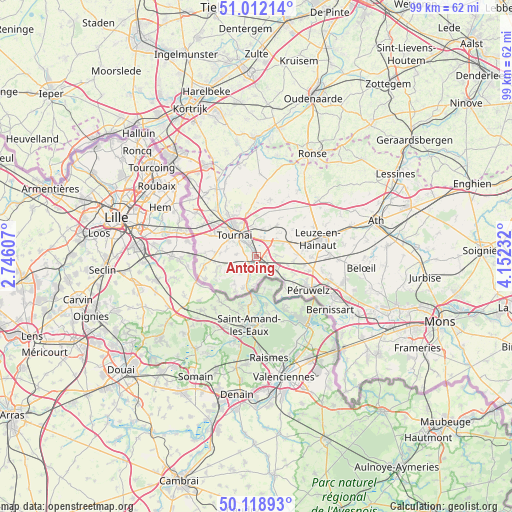
Antoing GPS coordinates[2]
50° 34' 3.54" North, 3° 26' 57.12" East
| Map corner | latitude | longitude |
|---|---|---|
| Upper-left | 51.01214°, | 2.74607° |
| Center: | 50.56765°, | 3.4492° |
| Lower-right: | 50.11893°, | 4.15232° |
| Map W x H: | 99.3×99.3 km | = 61.7×61.7mi |
| max Lat: | 51.46791° ⇑72.4% North |
| Antoing: | 50.56765° |
| min Lat: | ⇓27.6% South 49.53771° |
| min Long | Antoing | max Long |
| 2.59368° | 3.4492° | 6.25749° |
| W 13%⇐ | ⇒87% E |
Elevation
Elevation of Antoing is 31 m = 102 ft, and this is 68.5 m = 225 ft below average elevation for this country.
| Max E: |
582 m = 1909 ft | 61.2% |
| Avg. | 99.5 m = 326 ft | |
| Antoing | 31 m = 102 ft | |
Min E: |
1 m = 3 ft | 38.8% |
See also: Belgium elevation on elevation.city.
Geographical zone
Antoing is located in North temperate zone (between Tropic of Cancer and the Arctic Circle). Distance of this North polar circle is 1778.6 km =1105.2 mi to North.| Distance of | km | miles | from Antoing |
|---|---|---|---|
| North Pole | 4384.5 | 2724.4 | to North |
| Arctic Circle | 1778.6 | 1105.2 | to North |
| Tropic Cancer | 3016.7 | 1874.5 | to South |
| Equator | 5622.6 | 3493.7 | to South |


Nearby cities:
15 places around Antoing: (largest is in red/bold)
• Ath
24.2 km =15 mi,  73°
73°
• Avelgem
23.2 km =14.4 mi,  359°
359°
• Beloeil
20.3 km =12.6 mi,  95°
95°
• Bernissart
17.5 km =10.9 mi,  126°
126°
• Celles
16.1 km =10 mi,  2°
2°
• Estaimpuis
19.9 km =12.4 mi,  320°
320°
• Frasnes-lez-Anvaing
19.1 km =11.9 mi,  43°
43°
• Frasnes-lez-Buissenal
16.4 km =10.2 mi,  47°
47°
• Hensies
22.4 km =13.9 mi, 132°
• Pecq
15.3 km =9.5 mi,  329°
329°
• Péruwelz
12.2 km =7.6 mi,  122°
122°
• Quiévrain
24.3 km =15.1 mi,  137°
137°
• Ronse
22.5 km =14 mi,  28°
28°
• Rumes
10.3 km =6.4 mi,  261°
261°
• Tournai
6.1 km =3.8 mi, 316°
Sources, notices
• [Note1] Compared only with cities in Belgium existing in our database
• [Src1] Map data: © OpenStreetMap contributors (CC-BY-SA)
• [Src2] Other city data from geonames.org with taken over terms of usage.
• [Src3] Geographical zone / Annual Mean Temperature by Robert A. Rohde @ Wikipedia
