Frasnes-lez-Buissenal geodata
Frasnes-lez-Buissenal (Wallonia) is a populated place; located in Belgium in Europe/Brussels (GMT+2) time zone. With population of 10,936 people, there are 276 cities with bigger population in this country. Compared to other cities in Belgium, 62.1% of cities are located further ↑North; 83.9% of cities are located further →East and 57.8% of cities have higher elevation than Frasnes-lez-Buissenal. Note1
Administrative division(s):
- Level 1: Wallonia
- Level 2: Province du Hainaut
- Level 3: Arrondissement d'Ath
- Level 4: Frasnes-lez-Anvaing
Current local time in Frasnes-lez-Buissenal:
11:17 AM, ThursdayDifference from your time zone: hours


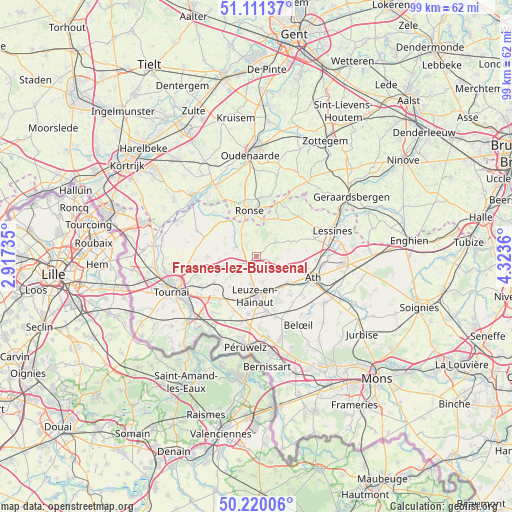
Frasnes-lez-Buissenal GPS coordinates[2]
50° 40' 4.188" North, 3° 37' 13.692" East
| Map corner | latitude | longitude |
|---|---|---|
| Upper-left | 51.11137°, | 2.91735° |
| Center: | 50.66783°, | 3.62047° |
| Lower-right: | 50.22006°, | 4.3236° |
| Map W x H: | 99.1×99.1 km | = 61.6×61.6mi |
| max Lat: | 51.46791° ⇑62.1% North |
| Frasnes-lez-Buissenal: | 50.66783° |
| min Lat: | ⇓37.9% South 49.53771° |
| min Long | Frasnes-lez-Bui | max Long |
| 2.59368° | 3.62047° | 6.25749° |
| W 16.1%⇐ | ⇒83.9% E |
Elevation
Elevation of Frasnes-lez-Buissenal is 38 m = 125 ft, and this is 61.5 m = 202 ft below average elevation for this country.
| Max E: |
582 m = 1909 ft | 57.8% |
| Avg. | 99.5 m = 326 ft | |
| Frasnes-lez-Buissenal | 38 m = 125 ft | |
Min E: |
1 m = 3 ft | 42.2% |
See also: Belgium elevation on elevation.city.
Geographical zone
Frasnes-lez-Buissenal is located in North temperate zone (between Tropic of Cancer and the Arctic Circle). Distance of this North polar circle is 1767.4 km =1098.2 mi to North.| Distance of | km | miles | from Frasnes-lez-Buissenal |
|---|---|---|---|
| North Pole | 4373.3 | 2717.4 | to North |
| Arctic Circle | 1767.4 | 1098.2 | to North |
| Tropic Cancer | 3027.8 | 1881.4 | to South |
| Equator | 5633.7 | 3500.6 | to South |


Nearby cities:
15 places around Frasnes-lez-Buissenal: (largest is in red/bold)
• Antoing
16.4 km =10.2 mi,  227°
227°
• Ath
11.9 km =7.4 mi,  111°
111°
• Avelgem
17.3 km =10.7 mi,  314°
314°
• Beloeil
15.3 km =9.5 mi,  148°
148°
• Brugelette
18.3 km =11.4 mi,  115°
115°
• Celles
12.5 km =7.8 mi,  293°
293°
• Chièvres
15.9 km =9.9 mi, 124°
• Ellezelles
8.6 km =5.3 mi,  29°
29°
• Flobecq
11.4 km =7.1 mi,  47°
47°
• Frasnes-lez-Anvaing
2.9 km =1.8 mi,  21°
21°
• Lessines
15.9 km =9.9 mi,  72°
72°
• Pecq
20 km =12.4 mi,  275°
275°
• Péruwelz
17.9 km =11.1 mi,  186°
186°
• Ronse
8.8 km =5.5 mi,  350°
350°
• Tournai
17.6 km =10.9 mi,  247°
247°
Sources, notices
• [Note1] Compared only with cities in Belgium existing in our database
• [Src1] Map data: © OpenStreetMap contributors (CC-BY-SA)
• [Src2] Other city data from geonames.org with taken over terms of usage.
• [Src3] Geographical zone / Annual Mean Temperature by Robert A. Rohde @ Wikipedia
