Pecq geodata
Pecq (Wallonia) is a populated place; located in Belgium in Europe/Brussels (GMT+2) time zone. With population of 5,301 people, there are 444 cities with bigger population in this country. Compared to other cities in Belgium, 60.1% of cities are located further ↑North; 89.7% of cities are located further →East and 68.2% of cities have higher elevation than Pecq. Note1
Administrative division(s):
- Level 1: Wallonia
- Level 2: Province du Hainaut
- Level 3: Arrondissement de Tournai
- Level 4: Pecq


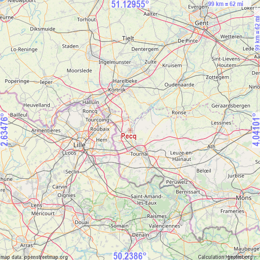
Pecq GPS coordinates[2]
50° 41' 10.284" North, 3° 20' 16.404" East
| Map corner | latitude | longitude |
|---|---|---|
| Upper-left | 51.12955°, | 2.63476° |
| Center: | 50.68619°, | 3.33789° |
| Lower-right: | 50.2386°, | 4.04101° |
| Map W x H: | 99.1×99.1 km | = 61.6×61.6mi |
| max Lat: | 51.46791° ⇑60.1% North |
| Pecq: | 50.68619° |
| min Lat: | ⇓39.9% South 49.53771° |
| min Long | Pecq | max Long |
| 2.59368° | 3.33789° | 6.25749° |
| W 10.3%⇐ | ⇒89.7% E |
Elevation
Elevation of Pecq is 23 m = 75 ft, and this is 76.5 m = 251 ft below average elevation for this country.
| Max E: |
582 m = 1909 ft | 68.2% |
| Avg. | 99.5 m = 326 ft | |
| Pecq | 23 m = 75 ft | |
Min E: |
1 m = 3 ft | 31.8% |
See also: Belgium elevation on elevation.city.
Geographical zone
Pecq is located in North temperate zone (between Tropic of Cancer and the Arctic Circle). Distance of this North polar circle is 1765.4 km =1097 mi to North.| Distance of | km | miles | from Pecq |
|---|---|---|---|
| North Pole | 4371.3 | 2716.2 | to North |
| Arctic Circle | 1765.4 | 1097 | to North |
| Tropic Cancer | 3029.9 | 1882.7 | to South |
| Equator | 5635.8 | 3501.9 | to South |


Nearby cities:
15 places around Pecq: (largest is in red/bold)
• Antoing
15.3 km =9.5 mi,  149°
149°
• Anzegem
19.4 km =12.1 mi,  30°
30°
• Avelgem
12.5 km =7.8 mi,  36°
36°
• Celles
8.9 km =5.5 mi,  70°
70°
• Deerlijk
18.6 km =11.6 mi,  3°
3°
• Estaimpuis
5.4 km =3.4 mi,  292°
292°
• Harelbeke
18.7 km =11.6 mi,  353°
353°
• Kortrijk
16.6 km =10.3 mi,  341°
341°
• Kuurne
18.8 km =11.7 mi, 348°
• Menen
19.5 km =12.1 mi,  309°
309°
• Mouscron
11.3 km =7 mi, 305°
• Rumes
14.8 km =9.2 mi,  188°
188°
• Tournai
9.5 km =5.9 mi,  157°
157°
• Wevelgem
17.5 km =10.9 mi,  316°
316°
• Zwevegem
14.1 km =8.8 mi, 0°
Sources, notices
• [Note1] Compared only with cities in Belgium existing in our database
• [Src1] Map data: © OpenStreetMap contributors (CC-BY-SA)
• [Src2] Other city data from geonames.org with taken over terms of usage.
• [Src3] Geographical zone / Annual Mean Temperature by Robert A. Rohde @ Wikipedia
