Celles geodata
Celles (Wallonia) is a populated place; located in Belgium in Europe/Brussels (GMT+2) time zone. With population of 5,471 people, there are 437 cities with bigger population in this country. Compared to other cities in Belgium, 57.8% of cities are located further ↑North; 86.8% of cities are located further →East and 73.1% of cities have higher elevation than Celles. Note1
Administrative division(s):
- Level 1: Wallonia
- Level 2: Province du Hainaut
- Level 3: Arrondissement de Tournai
- Level 4: Celles


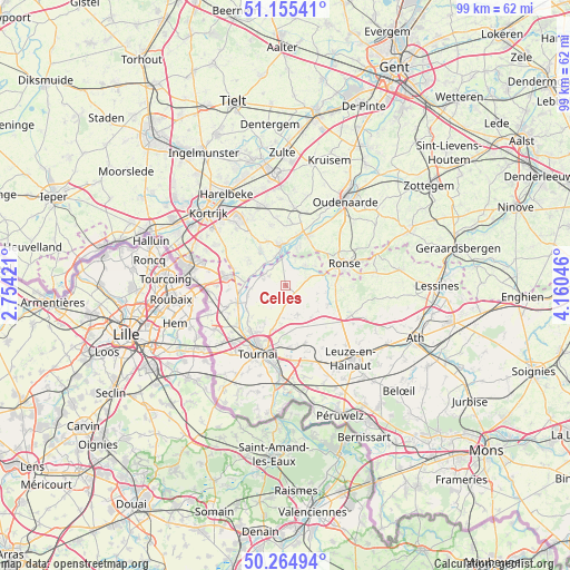
Celles GPS coordinates[2]
50° 42' 44.244" North, 3° 27' 26.388" East
| Map corner | latitude | longitude |
|---|---|---|
| Upper-left | 51.15541°, | 2.75421° |
| Center: | 50.71229°, | 3.45733° |
| Lower-right: | 50.26494°, | 4.16046° |
| Map W x H: | 99×99 km | = 61.5×61.5mi |
| max Lat: | 51.46791° ⇑57.8% North |
| Celles: | 50.71229° |
| min Lat: | ⇓42.2% South 49.53771° |
| min Long | Celles | max Long |
| 2.59368° | 3.45733° | 6.25749° |
| W 13.2%⇐ | ⇒86.8% E |
Elevation
Elevation of Celles is 19 m = 62 ft, and this is 80.5 m = 264 ft below average elevation for this country.
| Max E: |
582 m = 1909 ft | 73.1% |
| Avg. | 99.5 m = 326 ft | |
| Celles | 19 m = 62 ft | |
Min E: |
1 m = 3 ft | 26.9% |
See also: Belgium elevation on elevation.city.
Geographical zone
Celles is located in North temperate zone (between Tropic of Cancer and the Arctic Circle). Distance of this North polar circle is 1762.5 km =1095.2 mi to North.| Distance of | km | miles | from Celles |
|---|---|---|---|
| North Pole | 4368.4 | 2714.4 | to North |
| Arctic Circle | 1762.5 | 1095.2 | to North |
| Tropic Cancer | 3032.8 | 1884.5 | to South |
| Equator | 5638.7 | 3503.7 | to South |


Nearby cities:
15 places around Celles: (largest is in red/bold)
• Antoing
16.1 km =10 mi,  182°
182°
• Anzegem
13.9 km =8.6 mi,  5°
5°
• Avelgem
7.2 km =4.5 mi,  353°
353°
• Deerlijk
17.3 km =10.7 mi,  335°
335°
• Ellezelles
15.9 km =9.9 mi,  80°
80°
• Estaimpuis
13.4 km =8.3 mi,  266°
266°
• Frasnes-lez-Anvaing
12.8 km =8 mi,  100°
100°
• Frasnes-lez-Buissenal
12.5 km =7.8 mi,  113°
113°
• Kortrijk
18.7 km =11.6 mi,  313°
313°
• Mouscron
18 km =11.2 mi,  281°
281°
• Oudenaarde
18.8 km =11.7 mi,  34°
34°
• Pecq
8.9 km =5.5 mi,  250°
250°
• Ronse
10.7 km =6.6 mi,  69°
69°
• Tournai
12.6 km =7.8 mi,  202°
202°
• Zwevegem
13.9 km =8.6 mi,  323°
323°
Sources, notices
• [Note1] Compared only with cities in Belgium existing in our database
• [Src1] Map data: © OpenStreetMap contributors (CC-BY-SA)
• [Src2] Other city data from geonames.org with taken over terms of usage.
• [Src3] Geographical zone / Annual Mean Temperature by Robert A. Rohde @ Wikipedia
