Tournai geodata
Tournai (Wallonia) is a seat of a third-order administrative division; located in Belgium in Europe/Brussels (GMT+2) time zone. With population of 67,721 people, there are 17 cities with bigger population in this country. Compared to other cities in Belgium, 68.6% of cities are located further ↑North; 88.6% of cities are located further →East and 67.3% of cities have higher elevation than Tournai. Note1
Administrative division(s):
- Level 1: Wallonia
- Level 2: Province du Hainaut
- Level 3: Arrondissement de Tournai
- Level 4: Tournai


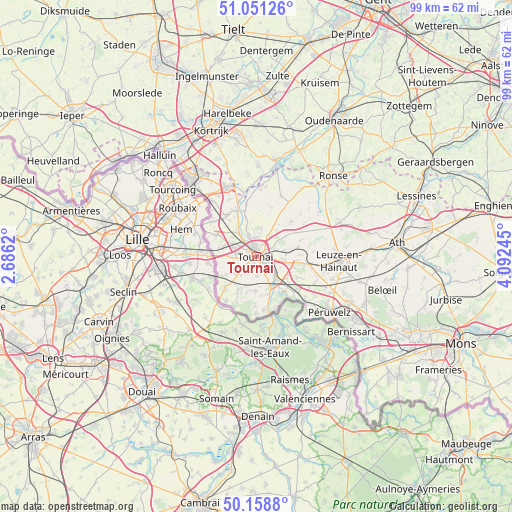
Tournai GPS coordinates[2]
50° 36' 25.74" North, 3° 23' 21.552" East
| Map corner | latitude | longitude |
|---|---|---|
| Upper-left | 51.05126°, | 2.6862° |
| Center: | 50.60715°, | 3.38932° |
| Lower-right: | 50.1588°, | 4.09245° |
| Map W x H: | 99.2×99.2 km | = 61.6×61.6mi |
| max Lat: | 51.46791° ⇑68.6% North |
| Tournai: | 50.60715° |
| min Lat: | ⇓31.4% South 49.53771° |
| min Long | Tournai | max Long |
| 2.59368° | 3.38932° | 6.25749° |
| W 11.4%⇐ | ⇒88.6% E |
Elevation
Elevation of Tournai is 24 m = 79 ft, and this is 75.5 m = 248 ft below average elevation for this country.
| Max E: |
582 m = 1909 ft | 67.3% |
| Avg. | 99.5 m = 326 ft | |
| Tournai | 24 m = 79 ft | |
Min E: |
1 m = 3 ft | 32.7% |
See also: Tournai elevation on elevation.city.
Geographical zone
Tournai is located in North temperate zone (between Tropic of Cancer and the Arctic Circle). Distance of this North polar circle is 1774.2 km =1102.4 mi to North.| Distance of | km | miles | from Tournai |
|---|---|---|---|
| North Pole | 4380.1 | 2721.7 | to North |
| Arctic Circle | 1774.2 | 1102.4 | to North |
| Tropic Cancer | 3021.1 | 1877.2 | to South |
| Equator | 5627 | 3496.5 | to South |


Nearby cities:
15 places around Tournai: (largest is in red/bold)
• Antoing
6.1 km =3.8 mi,  136°
136°
• Avelgem
19.2 km =11.9 mi,  11°
11°
• Beloeil
25.2 km =15.7 mi,  104°
104°
• Bernissart
23.6 km =14.7 mi,  128°
128°
• Celles
12.6 km =7.8 mi,  22°
22°
• Ellezelles
24.9 km =15.5 mi,  55°
55°
• Estaimpuis
13.8 km =8.6 mi,  321°
321°
• Frasnes-lez-Anvaing
19.8 km =12.3 mi, 61°
• Frasnes-lez-Buissenal
17.6 km =10.9 mi,  67°
67°
• Mouscron
20 km =12.4 mi, 319°
• Pecq
9.5 km =5.9 mi,  337°
337°
• Péruwelz
18.2 km =11.3 mi, 127°
• Ronse
21.4 km =13.3 mi,  43°
43°
• Rumes
8.3 km =5.2 mi,  225°
225°
• Zwevegem
23.1 km =14.4 mi,  351°
351°
Sources, notices
• [Note1] Compared only with cities in Belgium existing in our database
• [Src1] Map data: © OpenStreetMap contributors (CC-BY-SA)
• [Src2] Other city data from geonames.org with taken over terms of usage.
• [Src3] Geographical zone / Annual Mean Temperature by Robert A. Rohde @ Wikipedia
