Loumbila geodata
Loumbila (Plateau-Central) is a seat of a third-order administrative division; located in Burkina Faso in Africa/Ouagadougou (GMT+0) time zone. In our database, there are 49 cities with bigger population. Compared to other cities in Burkina Faso, 50.6% of cities are located further ↓South; 59.5% of cities are located further ←West and 67.1% of cities have higher elevation than Loumbila. Note1


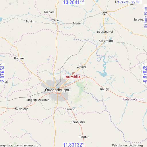
Loumbila GPS coordinates[2]
12° 31' 7.068" North, 1° 22' 24.24" West
| Map corner | latitude | longitude |
|---|---|---|
| Upper-left | 13.20411°, | -2.07653° |
| Center: | 12.51863°, | -1.3734° |
| Lower-right: | 11.83132°, | -0.67028° |
| Map W x H: | 152.6×152.6 km | = 94.8×94.8mi |
| max Lat: | 14.96549° ⇑49.4% North |
| Loumbila: | 12.51863° |
| min Lat: | ⇓50.6% South 9.88333° |
| min Long | Loumbila | max Long |
| -5.16667° | -1.3734° | 1.78838° |
| W 59.5%⇐ | ⇒40.5% E |
Elevation
Elevation of Loumbila is 295 m = 968 ft, and this is 8 m = 26 ft below average elevation for this country.
| Max E: |
423 m = 1388 ft | 67.1% |
| Avg. | 303 m = 994 ft | |
| Loumbila | 295 m = 968 ft | |
Min E: |
222 m = 728 ft | 32.9% |
See also: Burkina Faso elevation on elevation.city.
Geographical zone
Loumbila is located in North Torrid zone (between Equator and Tropic of Cancer). Distance of this Northern Tropic circle is 1214 km =754.3 mi to North.| Distance of | km | miles | from Loumbila |
|---|---|---|---|
| North Pole | 8615.1 | 5353.2 | to North |
| Arctic Circle | 6009.2 | 3733.9 | to North |
| Tropic Cancer | 1214 | 754.3 | to North |
| Equator | 1391.9 | 864.9 | to South |


Nearby cities:
15 places around Loumbila: (largest is in red/bold)
• Absouya
37.2 km =23.1 mi,  68°
68°
• Dapélogo
24.8 km =15.4 mi,  313°
313°
• Komsilga
46.5 km =28.9 mi,  217°
217°
• Korsimoro
47.6 km =29.6 mi,  44°
44°
• Koubri
35.8 km =22.2 mi,  185°
185°
• Laye
43.8 km =27.2 mi,  271°
271°
• Nagréongo
19.2 km =11.9 mi,  103°
103°
• Ouagadougou
24.3 km =15.1 mi,  225°
225°
• Ourgou-Manéga
32.5 km =20.2 mi,  333°
333°
• Pabré
23.1 km =14.4 mi, 270°
• Saaba
17 km =10.6 mi,  195°
195°
• Sourgoubila
48.4 km =30.1 mi,  256°
256°
• Tanghin-Dassouri
46.3 km =28.8 mi, 233°
• Ziniaré
10.9 km =6.8 mi,  49°
49°
• Zitenga
26.5 km =16.5 mi,  15°
15°
Sources, notices
• [Note1] Compared only with cities in Burkina Faso existing in our database
• [Src1] Map data: © OpenStreetMap contributors (CC-BY-SA)
• [Src2] Other city data from geonames.org with taken over terms of usage.
• [Src3] Geographical zone / Annual Mean Temperature by Robert A. Rohde @ Wikipedia
