Nagréongo geodata
Nagréongo (Plateau-Central) is a seat of a third-order administrative division; located in Burkina Faso in Africa/Ouagadougou (GMT+0) time zone. In our database, there are 49 cities with bigger population. Compared to other cities in Burkina Faso, 50.6% of cities are located further ↑North; 65.8% of cities are located further ←West and 88.6% of cities have higher elevation than Nagréongo. Note1


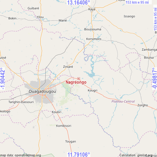
Nagréongo GPS coordinates[2]
12° 28' 42.492" North, 1° 12' 4.644" West
| Map corner | latitude | longitude |
|---|---|---|
| Upper-left | 13.16406°, | -1.90442° |
| Center: | 12.47847°, | -1.20129° |
| Lower-right: | 11.79106°, | -0.49817° |
| Map W x H: | 152.7×152.7 km | = 94.9×94.9mi |
| max Lat: | 14.96549° ⇑50.6% North |
| Nagréongo: | 12.47847° |
| min Lat: | ⇓49.4% South 9.88333° |
| min Long | Nagréongo | max Long |
| -5.16667° | -1.20129° | 1.78838° |
| W 65.8%⇐ | ⇒34.2% E |
Elevation
Elevation of Nagréongo is 270 m = 886 ft, and this is 33 m = 108 ft below average elevation for this country.
| Max E: |
423 m = 1388 ft | 88.6% |
| Avg. | 303 m = 994 ft | |
| Nagréongo | 270 m = 886 ft | |
Min E: |
222 m = 728 ft | 11.4% |
See also: Burkina Faso elevation on elevation.city.
Geographical zone
Nagréongo is located in North Torrid zone (between Equator and Tropic of Cancer). Distance of this Northern Tropic circle is 1218.4 km =757.1 mi to North.| Distance of | km | miles | from Nagréongo |
|---|---|---|---|
| North Pole | 8619.6 | 5356 | to North |
| Arctic Circle | 6013.7 | 3736.7 | to North |
| Tropic Cancer | 1218.4 | 757.1 | to North |
| Equator | 1387.5 | 862.2 | to South |


Nearby cities:
15 places around Nagréongo: (largest is in red/bold)
• Absouya
24.1 km =15 mi,  41°
41°
• Boussouma
49.8 km =30.9 mi,  15°
15°
• Dapélogo
42.5 km =26.4 mi,  300°
300°
• Gaongo
52.9 km =32.9 mi,  175°
175°
• Kombissiri
47.9 km =29.8 mi,  197°
197°
• Komsilga
57.1 km =35.5 mi,  235°
235°
• Korsimoro
41.2 km =25.6 mi, 20°
• Koubri
38.4 km =23.9 mi,  215°
215°
• Loumbila
19.2 km =11.9 mi,  283°
283°
• Ouagadougou
38.2 km =23.7 mi,  250°
250°
• Ourgou-Manéga
47.2 km =29.3 mi,  315°
315°
• Pabré
42.1 km =26.2 mi, 276°
• Saaba
26.1 km =16.2 mi, 242°
• Ziniaré
15.5 km =9.6 mi, 317°
• Zitenga
32.2 km =20 mi,  338°
338°
Sources, notices
• [Note1] Compared only with cities in Burkina Faso existing in our database
• [Src1] Map data: © OpenStreetMap contributors (CC-BY-SA)
• [Src2] Other city data from geonames.org with taken over terms of usage.
• [Src3] Geographical zone / Annual Mean Temperature by Robert A. Rohde @ Wikipedia
