Ziniaré geodata
Ziniaré (Plateau-Central) is a seat of a first-order administrative division; located in Burkina Faso in Africa/Ouagadougou (GMT+0) time zone. With population of 12,703 people, there are 32 cities with bigger population in this country. Compared to other cities in Burkina Faso, 57% of cities are located further ↓South; 64.6% of cities are located further ←West and 51.9% of cities have higher elevation than Ziniaré. Note1


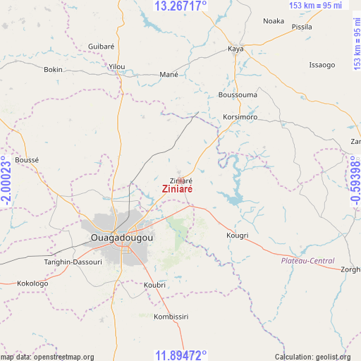
Ziniaré GPS coordinates[2]
12° 34' 54.696" North, 1° 17' 49.56" West
| Map corner | latitude | longitude |
|---|---|---|
| Upper-left | 13.26717°, | -2.00023° |
| Center: | 12.58186°, | -1.2971° |
| Lower-right: | 11.89472°, | -0.59398° |
| Map W x H: | 152.6×152.6 km | = 94.8×94.8mi |
| max Lat: | 14.96549° ⇑43% North |
| Ziniaré: | 12.58186° |
| min Lat: | ⇓57% South 9.88333° |
| min Long | Ziniaré | max Long |
| -5.16667° | -1.2971° | 1.78838° |
| W 64.6%⇐ | ⇒35.4% E |
Elevation
Elevation of Ziniaré is 303 m = 994 ft, and this is 0 m = 0 ft above average elevation for this country.
| Max E: |
423 m = 1388 ft | 51.9% |
| Ziniaré | 303 m 994 ft | |
| Avg. | 303 m = 994 ft | |
Min E: |
222 m = 728 ft | 48.1% |
See also: Burkina Faso elevation on elevation.city.
Geographical zone
Ziniaré is located in North Torrid zone (between Equator and Tropic of Cancer). Distance of this Northern Tropic circle is 1206.9 km =749.9 mi to North.| Distance of | km | miles | from Ziniaré |
|---|---|---|---|
| North Pole | 8608.1 | 5348.8 | to North |
| Arctic Circle | 6002.2 | 3729.6 | to North |
| Tropic Cancer | 1206.9 | 749.9 | to North |
| Equator | 1399 | 869.3 | to South |


Nearby cities:
15 places around Ziniaré: (largest is in red/bold)
• Absouya
27.1 km =16.8 mi,  76°
76°
• Boussouma
43.4 km =27 mi,  32°
32°
• Dapélogo
28.1 km =17.5 mi,  291°
291°
• Korsimoro
36.8 km =22.9 mi,  42°
42°
• Koubri
44.3 km =27.5 mi,  195°
195°
• Laye
52.4 km =32.6 mi,  263°
263°
• Loumbila
10.9 km =6.8 mi,  229°
229°
• Mané
45.5 km =28.3 mi,  353°
353°
• Nagréongo
15.5 km =9.6 mi,  137°
137°
• Ouagadougou
35.2 km =21.9 mi, 226°
• Ourgou-Manéga
31.7 km =19.7 mi,  313°
313°
• Pabré
32.1 km =19.9 mi, 257°
• Saaba
26.7 km =16.6 mi,  208°
208°
• Toéghin
53.5 km =33.2 mi,  299°
299°
• Zitenga
18.6 km =11.6 mi,  355°
355°
Sources, notices
• [Note1] Compared only with cities in Burkina Faso existing in our database
• [Src1] Map data: © OpenStreetMap contributors (CC-BY-SA)
• [Src2] Other city data from geonames.org with taken over terms of usage.
• [Src3] Geographical zone / Annual Mean Temperature by Robert A. Rohde @ Wikipedia
