Sapouy geodata
Sapouy (Centre-Ouest) is a seat of a second-order administrative division; located in Burkina Faso in Africa/Ouagadougou (GMT+0) time zone. With population of 3,837 people, there are 45 cities with bigger population in this country. Compared to other cities in Burkina Faso, 86.1% of cities are located further ↑North; 57% of cities are located further →East and 89.9% of cities have lower elevation than Sapouy. Note1


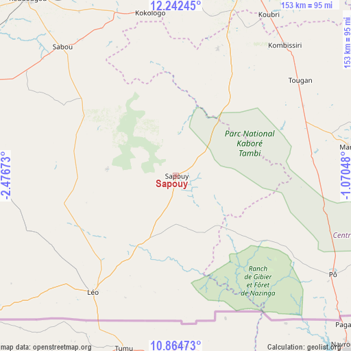
Sapouy GPS coordinates[2]
11° 33' 15.984" North, 1° 46' 24.996" West
| Map corner | latitude | longitude |
|---|---|---|
| Upper-left | 12.24245°, | -2.47673° |
| Center: | 11.55444°, | -1.77361° |
| Lower-right: | 10.86473°, | -1.07048° |
| Map W x H: | 153.2×153.2 km | = 95.2×95.2mi |
| max Lat: | 14.96549° ⇑86.1% North |
| Sapouy: | 11.55444° |
| min Lat: | ⇓13.9% South 9.88333° |
| min Long | Sapouy | max Long |
| -5.16667° | -1.77361° | 1.78838° |
| W 43%⇐ | ⇒57% E |
Elevation
Elevation of Sapouy is 336 m = 1102 ft, and this is 33 m = 108 ft above average elevation for this country.
| Max E: |
423 m = 1388 ft | 10.1% |
| Sapouy | 336 m 1102 ft | |
| Avg. | 303 m = 994 ft | |
Min E: |
222 m = 728 ft | 89.9% |
See also: Burkina Faso elevation on elevation.city.
Geographical zone
Sapouy is located in North Torrid zone (between Equator and Tropic of Cancer). Distance of Equator is 1284.7 km =798.3 mi to South.| Distance of | km | miles | from Sapouy |
|---|---|---|---|
| North Pole | 8722.3 | 5419.8 | to North |
| Arctic Circle | 6116.4 | 3800.6 | to North |
| Tropic Cancer | 1321.2 | 821 | to North |
| Equator | 1284.7 | 798.3 | to South |


Nearby cities:
15 places around Sapouy: (largest is in red/bold)
• Bingo
83.3 km =51.8 mi,  355°
355°
• Gaongo
83 km =51.6 mi,  52°
52°
• Goulouré
77.6 km =48.2 mi,  347°
347°
• Kayao
51.5 km =32 mi, 351°
• Kokologo
72 km =44.7 mi, 351°
• Kombissiri
74.4 km =46.2 mi,  39°
39°
• Komki-Ipala
69.9 km =43.4 mi, 358°
• Komsilga
71.9 km =44.7 mi,  12°
12°
• Koubri
81.9 km =50.9 mi,  29°
29°
• Léo
62.2 km =38.6 mi,  215°
215°
• Manga
77.3 km =48 mi,  80°
80°
• Pitmoaga
77.7 km =48.3 mi, 351°
• Pô
80.8 km =50.2 mi,  121°
121°
• Saponé
58.5 km =36.4 mi,  18°
18°
• Tanghin-Dassouri
80.1 km =49.8 mi,  4°
4°
Sources, notices
• [Note1] Compared only with cities in Burkina Faso existing in our database
• [Src1] Map data: © OpenStreetMap contributors (CC-BY-SA)
• [Src2] Other city data from geonames.org with taken over terms of usage.
• [Src3] Geographical zone / Annual Mean Temperature by Robert A. Rohde @ Wikipedia
