Balgarevo geodata
Balgarevo (Varna) is a populated place; located in Bulgaria in Europe/Sofia (GMT+3) time zone. With population of 1,375 people, there are 254 cities with bigger population in this country. Compared to other cities in Bulgaria, 75.7% of cities are located further ↓South; 99.7% of cities are located further ←West and 81.7% of cities have higher elevation than Balgarevo. Note1


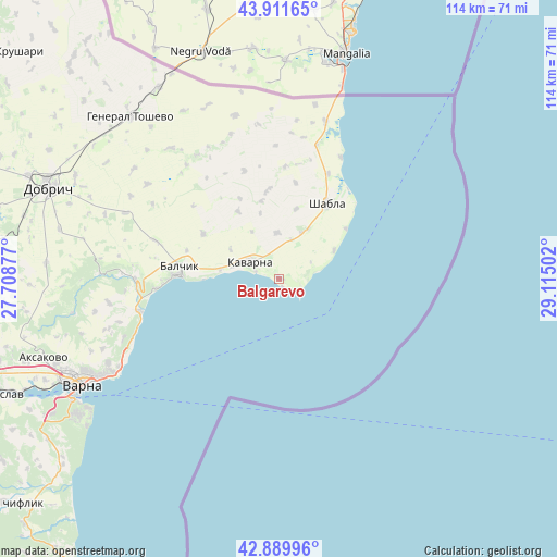
Balgarevo GPS coordinates[2]
43° 24' 10.656" North, 28° 24' 42.804" East
| Map corner | latitude | longitude |
|---|---|---|
| Upper-left | 43.91165°, | 27.70877° |
| Center: | 43.40296°, | 28.41189° |
| Lower-right: | 42.88996°, | 29.11502° |
| Map W x H: | 113.6×113.6 km | = 70.6×70.6mi |
| max Lat: | 44.16214° ⇑24.3% North |
| Balgarevo: | 43.40296° |
| min Lat: | ⇓75.7% South 41.32715° |
| min Long | Balgarevo | max Long |
| 22.52139° | 28.41189° | 28.53429° |
| W 99.7%⇐ | ⇒0.3% E |
Elevation
Elevation of Balgarevo is 91 m = 299 ft, and this is 225.6 m = 740 ft below average elevation for this country.
| Max E: |
1221 m = 4006 ft | 81.7% |
| Avg. | 316.6 m = 1039 ft | |
| Balgarevo | 91 m = 299 ft | |
Min E: |
1 m = 3 ft | 18.3% |
See also: Bulgaria elevation on elevation.city.
Geographical zone
Balgarevo is located in North temperate zone (between Tropic of Cancer and the Arctic Circle). Distance of this Northern Tropic circle is 2220 km =1379.4 mi to South.| Distance of | km | miles | from Balgarevo |
|---|---|---|---|
| North Pole | 5181.1 | 3219.4 | to North |
| Arctic Circle | 2575.2 | 1600.2 | to North |
| Tropic Cancer | 2220 | 1379.4 | to South |
| Equator | 4826 | 2998.7 | to South |


Nearby cities:
15 places around Balgarevo: (largest is in red/bold)
• Aksakovo
50.5 km =31.4 mi,  251°
251°
• Asparuhovo
49.1 km =30.5 mi,  239°
239°
• Avren
68.2 km =42.4 mi, 242°
• Balchik
20.6 km =12.8 mi,  275°
275°
• Beloslav
62 km =38.5 mi, 247°
• Bliznatsi
57.7 km =35.9 mi,  229°
229°
• Dobrich
50.1 km =31.1 mi,  291°
291°
• General Toshevo
44.8 km =27.8 mi,  317°
317°
• Kavarna
6.9 km =4.3 mi,  302°
302°
• Kranevo
29.4 km =18.3 mi,  256°
256°
• Shabla
18.1 km =11.2 mi,  32°
32°
• Spasovo
34.3 km =21.3 mi,  345°
345°
• Suvorovo
66.2 km =41.1 mi, 263°
• Varna
45.1 km =28 mi, 242°
• Zlatni Pyasatsi
32.7 km =20.3 mi, 246°
Sources, notices
• [Note1] Compared only with cities in Bulgaria existing in our database
• [Src1] Map data: © OpenStreetMap contributors (CC-BY-SA)
• [Src2] Other city data from geonames.org with taken over terms of usage.
• [Src3] Geographical zone / Annual Mean Temperature by Robert A. Rohde @ Wikipedia
