Balchik geodata
Balchik (Dobrich) is a seat of a second-order administrative division; located in Bulgaria in Europe/Sofia (GMT+3) time zone. With population of 13,000 people, there are 65 cities with bigger population in this country. Compared to other cities in Bulgaria, 76.7% of cities are located further ↓South; 98.7% of cities are located further ←West and 58% of cities have higher elevation than Balchik. Note1


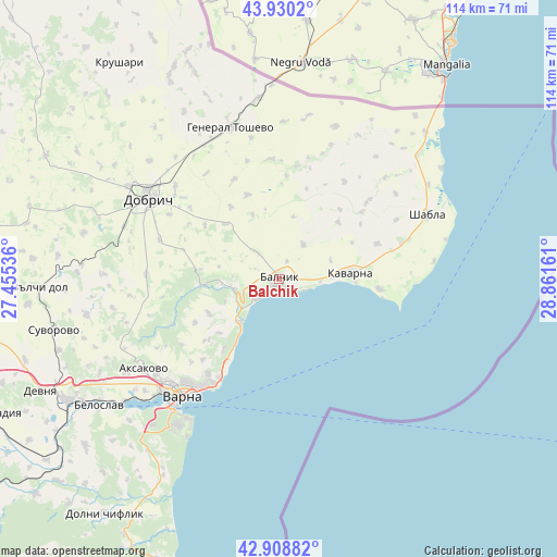
Balchik GPS coordinates[2]
43° 25' 17.976" North, 28° 9' 30.528" East
| Map corner | latitude | longitude |
|---|---|---|
| Upper-left | 43.9302°, | 27.45536° |
| Center: | 43.42166°, | 28.15848° |
| Lower-right: | 42.90882°, | 28.86161° |
| Map W x H: | 113.6×113.6 km | = 70.6×70.6mi |
| max Lat: | 44.16214° ⇑23.3% North |
| Balchik: | 43.42166° |
| min Lat: | ⇓76.7% South 41.32715° |
| min Long | Balchik | max Long |
| 22.52139° | 28.15848° | 28.53429° |
| W 98.7%⇐ | ⇒1.3% E |
Elevation
Elevation of Balchik is 191 m = 627 ft, and this is 125.6 m = 412 ft below average elevation for this country.
| Max E: |
1221 m = 4006 ft | 58% |
| Avg. | 316.6 m = 1039 ft | |
| Balchik | 191 m = 627 ft | |
Min E: |
1 m = 3 ft | 42% |
See also: Bulgaria elevation on elevation.city.
Geographical zone
Balchik is located in North temperate zone (between Tropic of Cancer and the Arctic Circle). Distance of this Northern Tropic circle is 2222.1 km =1380.7 mi to South.| Distance of | km | miles | from Balchik |
|---|---|---|---|
| North Pole | 5179 | 3218.1 | to North |
| Arctic Circle | 2573.1 | 1598.8 | to North |
| Tropic Cancer | 2222.1 | 1380.7 | to South |
| Equator | 4828 | 3000 | to South |


Nearby cities:
15 places around Balchik: (largest is in red/bold)
• Aksakovo
32.9 km =20.4 mi,  236°
236°
• Asparuhovo
34.6 km =21.5 mi,  219°
219°
• Balgarevo
20.6 km =12.8 mi,  95°
95°
• Beloslav
44.9 km =27.9 mi,  234°
234°
• Bliznatsi
45.9 km =28.5 mi,  210°
210°
• Dobrich
30.8 km =19.1 mi,  301°
301°
• General Toshevo
32.6 km =20.3 mi,  342°
342°
• Kavarna
14.7 km =9.1 mi,  83°
83°
• Kranevo
12.1 km =7.5 mi, 222°
• Shabla
33 km =20.5 mi,  66°
66°
• Spasovo
33.3 km =20.7 mi,  20°
20°
• Suvorovo
46.3 km =28.8 mi,  257°
257°
• Valchidol
49.2 km =30.6 mi,  267°
267°
• Varna
30 km =18.6 mi, 220°
• Zlatni Pyasatsi
17.9 km =11.1 mi, 211°
Sources, notices
• [Note1] Compared only with cities in Bulgaria existing in our database
• [Src1] Map data: © OpenStreetMap contributors (CC-BY-SA)
• [Src2] Other city data from geonames.org with taken over terms of usage.
• [Src3] Geographical zone / Annual Mean Temperature by Robert A. Rohde @ Wikipedia
