Spasovo geodata
Spasovo (Dobrich) is a seat of a second-order administrative division; located in Bulgaria in Europe/Sofia (GMT+3) time zone. In our database, there are 288 cities with bigger population. Compared to other cities in Bulgaria, 90% of cities are located further ↓South; 99% of cities are located further ←West and 79.7% of cities have higher elevation than Spasovo. Note1


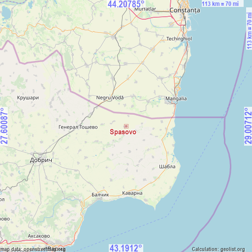
Spasovo GPS coordinates[2]
43° 42' 6.048" North, 28° 18' 14.364" East
| Map corner | latitude | longitude |
|---|---|---|
| Upper-left | 44.20785°, | 27.60087° |
| Center: | 43.70168°, | 28.30399° |
| Lower-right: | 43.1912°, | 29.00712° |
| Map W x H: | 113×113 km | = 70.2×70.2mi |
| max Lat: | 44.16214° ⇑10% North |
| Spasovo: | 43.70168° |
| min Lat: | ⇓90% South 41.32715° |
| min Long | Spasovo | max Long |
| 22.52139° | 28.30399° | 28.53429° |
| W 99%⇐ | ⇒1% E |
Elevation
Elevation of Spasovo is 100 m = 328 ft, and this is 216.6 m = 711 ft below average elevation for this country.
| Max E: |
1221 m = 4006 ft | 79.7% |
| Avg. | 316.6 m = 1039 ft | |
| Spasovo | 100 m = 328 ft | |
Min E: |
1 m = 3 ft | 20.3% |
See also: Bulgaria elevation on elevation.city.
Geographical zone
Spasovo is located in North temperate zone (between Tropic of Cancer and the Arctic Circle). Distance of this Northern Tropic circle is 2253.3 km =1400.1 mi to South.| Distance of | km | miles | from Spasovo |
|---|---|---|---|
| North Pole | 5147.9 | 3198.8 | to North |
| Arctic Circle | 2542 | 1579.5 | to North |
| Tropic Cancer | 2253.3 | 1400.1 | to South |
| Equator | 4859.2 | 3019.4 | to South |


Nearby cities:
15 places around Spasovo: (largest is in red/bold)
• Aksakovo
63 km =39.1 mi,  218°
218°
• Asparuhovo
67 km =41.6 mi,  210°
210°
• Balchik
33.3 km =20.7 mi,  200°
200°
• Balgarevo
34.3 km =21.3 mi,  165°
165°
• Dobrich
40.7 km =25.3 mi,  248°
248°
• General Toshevo
21.4 km =13.3 mi,  269°
269°
• Kavarna
29.7 km =18.5 mi, 174°
• Kaynardzha
71.6 km =44.5 mi,  296°
296°
• Kranevo
44.7 km =27.8 mi, 206°
• Krushari
45.9 km =28.5 mi,  286°
286°
• Shabla
25.8 km =16 mi,  134°
134°
• Suvorovo
70.2 km =43.6 mi,  234°
234°
• Valchidol
69.4 km =43.1 mi,  241°
241°
• Varna
62.3 km =38.7 mi, 210°
• Zlatni Pyasatsi
50.9 km =31.6 mi, 204°
Sources, notices
• [Note1] Compared only with cities in Bulgaria existing in our database
• [Src1] Map data: © OpenStreetMap contributors (CC-BY-SA)
• [Src2] Other city data from geonames.org with taken over terms of usage.
• [Src3] Geographical zone / Annual Mean Temperature by Robert A. Rohde @ Wikipedia
