Kavarna geodata
Kavarna (Dobrich) is a seat of a second-order administrative division; located in Bulgaria in Europe/Sofia (GMT+3) time zone. With population of 11,205 people, there are 73 cities with bigger population in this country. Compared to other cities in Bulgaria, 77.7% of cities are located further ↓South; 99.3% of cities are located further ←West and 73% of cities have higher elevation than Kavarna. Note1


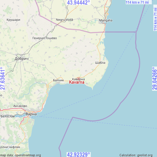
Kavarna GPS coordinates[2]
43° 26' 9.636" North, 28° 20' 22.308" East
| Map corner | latitude | longitude |
|---|---|---|
| Upper-left | 43.94442°, | 27.63641° |
| Center: | 43.43601°, | 28.33953° |
| Lower-right: | 42.92329°, | 29.04266° |
| Map W x H: | 113.5×113.5 km | = 70.5×70.5mi |
| max Lat: | 44.16214° ⇑22.3% North |
| Kavarna: | 43.43601° |
| min Lat: | ⇓77.7% South 41.32715° |
| min Long | Kavarna | max Long |
| 22.52139° | 28.33953° | 28.53429° |
| W 99.3%⇐ | ⇒0.7% E |
Elevation
Elevation of Kavarna is 129 m = 423 ft, and this is 187.6 m = 615 ft below average elevation for this country.
| Max E: |
1221 m = 4006 ft | 73% |
| Avg. | 316.6 m = 1039 ft | |
| Kavarna | 129 m = 423 ft | |
Min E: |
1 m = 3 ft | 27% |
See also: Bulgaria elevation on elevation.city.
Geographical zone
Kavarna is located in North temperate zone (between Tropic of Cancer and the Arctic Circle). Distance of this Northern Tropic circle is 2223.7 km =1381.7 mi to South.| Distance of | km | miles | from Kavarna |
|---|---|---|---|
| North Pole | 5177.4 | 3217.1 | to North |
| Arctic Circle | 2571.5 | 1597.9 | to North |
| Tropic Cancer | 2223.7 | 1381.7 | to South |
| Equator | 4829.6 | 3001 | to South |


Nearby cities:
15 places around Kavarna: (largest is in red/bold)
• Aksakovo
46.4 km =28.8 mi,  244°
244°
• Asparuhovo
46.3 km =28.8 mi,  232°
232°
• Balchik
14.7 km =9.1 mi,  263°
263°
• Balgarevo
6.9 km =4.3 mi,  122°
122°
• Beloslav
58.2 km =36.2 mi, 241°
• Bliznatsi
56 km =34.8 mi,  223°
223°
• Dobrich
43.3 km =26.9 mi,  289°
289°
• General Toshevo
38.2 km =23.7 mi,  320°
320°
• Kranevo
25.1 km =15.6 mi,  245°
245°
• Krushari
63.3 km =39.3 mi,  312°
312°
• Shabla
19.5 km =12.1 mi,  53°
53°
• Spasovo
29.7 km =18.5 mi,  354°
354°
• Suvorovo
61 km =37.9 mi, 258°
• Varna
42 km =26.1 mi, 234°
• Zlatni Pyasatsi
29.3 km =18.2 mi, 235°
Sources, notices
• [Note1] Compared only with cities in Bulgaria existing in our database
• [Src1] Map data: © OpenStreetMap contributors (CC-BY-SA)
• [Src2] Other city data from geonames.org with taken over terms of usage.
• [Src3] Geographical zone / Annual Mean Temperature by Robert A. Rohde @ Wikipedia
