Blagoevgrad geodata
Blagoevgrad is a seat of a first-order administrative division; located in Bulgaria in Europe/Sofia (GMT+3) time zone. With population of 71,306 people, there are 14 cities with bigger population in this country. Compared to other cities in Bulgaria, 85% of cities are located further ↑North; 89.3% of cities are located further →East and 69.7% of cities have lower elevation than Blagoevgrad. Note1


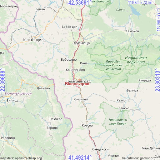
Blagoevgrad GPS coordinates[2]
42° 1' 0.012" North, 23° 6' 0" East
| Map corner | latitude | longitude |
|---|---|---|
| Upper-left | 42.53691°, | 22.39688° |
| Center: | 42.01667°, | 23.1° |
| Lower-right: | 41.49214°, | 23.80313° |
| Map W x H: | 116.2×116.2 km | = 72.2×72.2mi |
| max Lat: | 44.16214° ⇑85% North |
| Blagoevgrad: | 42.01667° |
| min Lat: | ⇓15% South 41.32715° |
| min Long | Blagoevgrad | max Long |
| 22.52139° | 23.1° | 28.53429° |
| W 10.7%⇐ | ⇒89.3% E |
Elevation
Elevation of Blagoevgrad is 390 m = 1280 ft, and this is 73.4 m = 241 ft above average elevation for this country.
| Max E: |
1221 m = 4006 ft | 30.3% |
| Blagoevgrad | 390 m 1280 ft | |
| Avg. | 316.6 m = 1039 ft | |
Min E: |
1 m = 3 ft | 69.7% |
See also: Blagoevgrad elevation on elevation.city.
Geographical zone
Blagoevgrad is located in North temperate zone (between Tropic of Cancer and the Arctic Circle). Distance of this Northern Tropic circle is 2065.9 km =1283.7 mi to South.| Distance of | km | miles | from Blagoevgrad |
|---|---|---|---|
| North Pole | 5335.2 | 3315.1 | to North |
| Arctic Circle | 2729.4 | 1696 | to North |
| Tropic Cancer | 2065.9 | 1283.7 | to South |
| Equator | 4671.8 | 2902.9 | to South |


Nearby cities:
15 places around Blagoevgrad: (largest is in red/bold)
• Bansko
37.8 km =23.5 mi,  121°
121°
• Belitsa
39.6 km =24.6 mi,  99°
99°
• Boboshevo
17.2 km =10.7 mi,  331°
331°
• Bobov Dol
39.3 km =24.4 mi,  348°
348°
• Borovets
11.9 km =7.4 mi, 326°
• Dupnitsa
27.8 km =17.3 mi,  2°
2°
• Kocherinovo
8.3 km =5.2 mi, 334°
• Kresna
31.8 km =19.8 mi,  172°
172°
• Nevestino
33.5 km =20.8 mi,  322°
322°
• Porominovo
6.7 km =4.2 mi, 350°
• Razlog
33.6 km =20.9 mi, 115°
• Rila
13.3 km =8.3 mi,  11°
11°
• Sapareva Banya
32.7 km =20.3 mi,  24°
24°
• Simitli
14.9 km =9.3 mi, 174°
• Stara Kresna
25.1 km =15.6 mi,  164°
164°
Sources, notices
• [Note1] Compared only with cities in Bulgaria existing in our database
• [Src1] Map data: © OpenStreetMap contributors (CC-BY-SA)
• [Src2] Other city data from geonames.org with taken over terms of usage.
• [Src3] Geographical zone / Annual Mean Temperature by Robert A. Rohde @ Wikipedia
