Antonovo geodata
Antonovo (Targovishte) is a populated place; located in Bulgaria in Europe/Sofia (GMT+3) time zone. With population of 1,543 people, there are 246 cities with bigger population in this country. Compared to other cities in Bulgaria, 62% of cities are located further ↓South; 69.3% of cities are located further ←West and 75.7% of cities have lower elevation than Antonovo. Note1


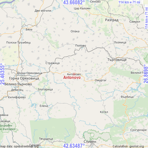
Antonovo GPS coordinates[2]
43° 9' 0" North, 26° 10' 0.012" East
| Map corner | latitude | longitude |
|---|---|---|
| Upper-left | 43.66082°, | 25.46355° |
| Center: | 43.15°, | 26.16667° |
| Lower-right: | 42.63487°, | 26.8698° |
| Map W x H: | 114.1×114.1 km | = 70.9×70.9mi |
| max Lat: | 44.16214° ⇑38% North |
| Antonovo: | 43.15° |
| min Lat: | ⇓62% South 41.32715° |
| min Long | Antonovo | max Long |
| 22.52139° | 26.16667° | 28.53429° |
| W 69.3%⇐ | ⇒30.7% E |
Elevation
Elevation of Antonovo is 481 m = 1578 ft, and this is 164.4 m = 539 ft above average elevation for this country.
| Max E: |
1221 m = 4006 ft | 24.3% |
| Antonovo | 481 m 1578 ft | |
| Avg. | 316.6 m = 1039 ft | |
Min E: |
1 m = 3 ft | 75.7% |
See also: Bulgaria elevation on elevation.city.
Geographical zone
Antonovo is located in North temperate zone (between Tropic of Cancer and the Arctic Circle). Distance of this Northern Tropic circle is 2191.9 km =1362 mi to South.| Distance of | km | miles | from Antonovo |
|---|---|---|---|
| North Pole | 5209.2 | 3236.8 | to North |
| Arctic Circle | 2603.3 | 1617.6 | to North |
| Tropic Cancer | 2191.9 | 1362 | to South |
| Equator | 4797.8 | 2981.2 | to South |


Nearby cities:
15 places around Antonovo: (largest is in red/bold)
• Debelets
46.5 km =28.9 mi,  253°
253°
• Elena
33.3 km =20.7 mi,  223°
223°
• Gorna Oryahovitsa
37.8 km =23.5 mi,  266°
266°
• Kotel
37.5 km =23.3 mi,  142°
142°
• Loznitsa
42.6 km =26.5 mi,  55°
55°
• Lyaskovets
35.8 km =22.2 mi,  263°
263°
• Omurtag
21 km =13 mi,  105°
105°
• Opaka
33.4 km =20.8 mi,  0°
0°
• Parvomaytsi
41.9 km =26 mi, 270°
• Popovo
22.9 km =14.2 mi,  13°
13°
• Strazhitsa
18.7 km =11.6 mi,  299°
299°
• Targovishte
34.7 km =21.6 mi,  71°
71°
• Varbitsa
41.4 km =25.7 mi, 113°
• Veliko Tŭrnovo
44.3 km =27.5 mi, 260°
• Zlataritsa
24.3 km =15.1 mi,  242°
242°
Sources, notices
• [Note1] Compared only with cities in Bulgaria existing in our database
• [Src1] Map data: © OpenStreetMap contributors (CC-BY-SA)
• [Src2] Other city data from geonames.org with taken over terms of usage.
• [Src3] Geographical zone / Annual Mean Temperature by Robert A. Rohde @ Wikipedia
