Omurtag geodata
Omurtag (Targovishte) is a populated place; located in Bulgaria in Europe/Sofia (GMT+3) time zone. With population of 9,070 people, there are 85 cities with bigger population in this country. Compared to other cities in Bulgaria, 60% of cities are located further ↓South; 73% of cities are located further ←West and 81.7% of cities have lower elevation than Omurtag. Note1


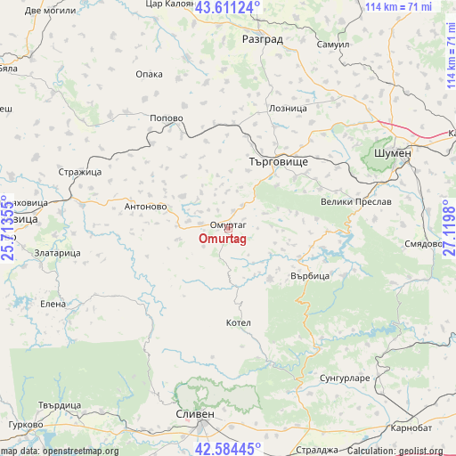
Omurtag GPS coordinates[2]
43° 6' 0" North, 26° 25' 0.012" East
| Map corner | latitude | longitude |
|---|---|---|
| Upper-left | 43.61124°, | 25.71355° |
| Center: | 43.1°, | 26.41667° |
| Lower-right: | 42.58445°, | 27.1198° |
| Map W x H: | 114.2×114.2 km | = 71×71mi |
| max Lat: | 44.16214° ⇑40% North |
| Omurtag: | 43.1° |
| min Lat: | ⇓60% South 41.32715° |
| min Long | Omurtag | max Long |
| 22.52139° | 26.41667° | 28.53429° |
| W 73%⇐ | ⇒27% E |
Elevation
Elevation of Omurtag is 559 m = 1834 ft, and this is 242.4 m = 795 ft above average elevation for this country.
| Max E: |
1221 m = 4006 ft | 18.3% |
| Omurtag | 559 m 1834 ft | |
| Avg. | 316.6 m = 1039 ft | |
Min E: |
1 m = 3 ft | 81.7% |
See also: Bulgaria elevation on elevation.city.
Geographical zone
Omurtag is located in North temperate zone (between Tropic of Cancer and the Arctic Circle). Distance of this Northern Tropic circle is 2186.4 km =1358.6 mi to South.| Distance of | km | miles | from Omurtag |
|---|---|---|---|
| North Pole | 5214.8 | 3240.3 | to North |
| Arctic Circle | 2608.9 | 1621.1 | to North |
| Tropic Cancer | 2186.4 | 1358.6 | to South |
| Equator | 4792.3 | 2977.8 | to South |


Nearby cities:
15 places around Omurtag: (largest is in red/bold)
• Antonovo
21 km =13 mi,  285°
285°
• Elena
47.2 km =29.3 mi,  246°
246°
• Kotel
24.2 km =15 mi,  173°
173°
• Loznitsa
33.2 km =20.6 mi,  26°
26°
• Opaka
43.9 km =27.3 mi,  332°
332°
• Popovo
31.5 km =19.6 mi, 331°
• Razgrad
48.9 km =30.4 mi,  9°
9°
• Shumen
45.2 km =28.1 mi,  65°
65°
• Sliven
46.6 km =29 mi,  188°
188°
• Strazhitsa
39.4 km =24.5 mi, 292°
• Sungurlare
47.6 km =29.6 mi,  141°
141°
• Targovishte
21 km =13 mi,  36°
36°
• Varbitsa
20.8 km =12.9 mi,  122°
122°
• Veliki Preslav
33.3 km =20.7 mi,  77°
77°
• Zlataritsa
42.3 km =26.3 mi,  262°
262°
Sources, notices
• [Note1] Compared only with cities in Bulgaria existing in our database
• [Src1] Map data: © OpenStreetMap contributors (CC-BY-SA)
• [Src2] Other city data from geonames.org with taken over terms of usage.
• [Src3] Geographical zone / Annual Mean Temperature by Robert A. Rohde @ Wikipedia
