Kotel geodata
Kotel (Sliven) is a populated place; located in Bulgaria in Europe/Sofia (GMT+3) time zone. With population of 6,421 people, there are 115 cities with bigger population in this country. Compared to other cities in Bulgaria, 52% of cities are located further ↓South; 73.3% of cities are located further ←West and 77% of cities have lower elevation than Kotel. Note1


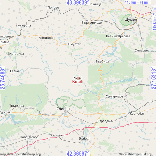
Kotel GPS coordinates[2]
42° 52' 59.988" North, 26° 27' 0" East
| Map corner | latitude | longitude |
|---|---|---|
| Upper-left | 43.39639°, | 25.74688° |
| Center: | 42.88333°, | 26.45° |
| Lower-right: | 42.36597°, | 27.15313° |
| Map W x H: | 114.6×114.6 km | = 71.2×71.2mi |
| max Lat: | 44.16214° ⇑48% North |
| Kotel: | 42.88333° |
| min Lat: | ⇓52% South 41.32715° |
| min Long | Kotel | max Long |
| 22.52139° | 26.45° | 28.53429° |
| W 73.3%⇐ | ⇒26.7% E |
Elevation
Elevation of Kotel is 494 m = 1621 ft, and this is 177.4 m = 582 ft above average elevation for this country.
| Max E: |
1221 m = 4006 ft | 23% |
| Kotel | 494 m 1621 ft | |
| Avg. | 316.6 m = 1039 ft | |
Min E: |
1 m = 3 ft | 77% |
See also: Bulgaria elevation on elevation.city.
Geographical zone
Kotel is located in North temperate zone (between Tropic of Cancer and the Arctic Circle). Distance of this Northern Tropic circle is 2162.3 km =1343.6 mi to South.| Distance of | km | miles | from Kotel |
|---|---|---|---|
| North Pole | 5238.9 | 3255.3 | to North |
| Arctic Circle | 2633 | 1636.1 | to North |
| Tropic Cancer | 2162.3 | 1343.6 | to South |
| Equator | 4768.2 | 2962.8 | to South |


Nearby cities:
15 places around Kotel: (largest is in red/bold)
• Antonovo
37.5 km =23.3 mi,  322°
322°
• Elena
46.5 km =28.9 mi,  276°
276°
• Karnobat
50.7 km =31.5 mi,  120°
120°
• Kermen
45.6 km =28.3 mi,  200°
200°
• Omurtag
24.2 km =15 mi,  353°
353°
• Sliven
24.1 km =15 mi, 204°
• Smyadovo
50.4 km =31.3 mi,  66°
66°
• Straldzha
36.8 km =22.9 mi,  148°
148°
• Sungurlare
30.1 km =18.7 mi, 115°
• Targovishte
42.1 km =26.2 mi,  13°
13°
• Tvarditsa
49.3 km =30.6 mi,  245°
245°
• Varbitsa
19.8 km =12.3 mi,  48°
48°
• Veliki Preslav
43.4 km =27 mi,  43°
43°
• Yambol
44.7 km =27.8 mi,  174°
174°
• Zlataritsa
48.4 km =30.1 mi,  292°
292°
Sources, notices
• [Note1] Compared only with cities in Bulgaria existing in our database
• [Src1] Map data: © OpenStreetMap contributors (CC-BY-SA)
• [Src2] Other city data from geonames.org with taken over terms of usage.
• [Src3] Geographical zone / Annual Mean Temperature by Robert A. Rohde @ Wikipedia
