Asenovgrad geodata
Asenovgrad (Plovdiv) is a populated place; located in Bulgaria in Europe/Sofia (GMT+3) time zone. With population of 52,170 people, there are 20 cities with bigger population in this country. Compared to other cities in Bulgaria, 85% of cities are located further ↑North; 54.7% of cities are located further →East and 50.7% of cities have lower elevation than Asenovgrad. Note1


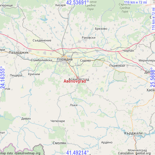
Asenovgrad GPS coordinates[2]
42° 1' 0.012" North, 24° 52' 0.012" East
| Map corner | latitude | longitude |
|---|---|---|
| Upper-left | 42.53691°, | 24.16355° |
| Center: | 42.01667°, | 24.86667° |
| Lower-right: | 41.49214°, | 25.5698° |
| Map W x H: | 116.2×116.2 km | = 72.2×72.2mi |
| max Lat: | 44.16214° ⇑85% North |
| Asenovgrad: | 42.01667° |
| min Lat: | ⇓15% South 41.32715° |
| min Long | Asenovgrad | max Long |
| 22.52139° | 24.86667° | 28.53429° |
| W 45.3%⇐ | ⇒54.7% E |
Elevation
Elevation of Asenovgrad is 226 m = 741 ft, and this is 90.6 m = 297 ft below average elevation for this country.
| Max E: |
1221 m = 4006 ft | 49.3% |
| Avg. | 316.6 m = 1039 ft | |
| Asenovgrad | 226 m = 741 ft | |
Min E: |
1 m = 3 ft | 50.7% |
See also: Asenovgrad elevation on elevation.city.
Geographical zone
Asenovgrad is located in North temperate zone (between Tropic of Cancer and the Arctic Circle). Distance of this Northern Tropic circle is 2065.9 km =1283.7 mi to South.| Distance of | km | miles | from Asenovgrad |
|---|---|---|---|
| North Pole | 5335.2 | 3315.1 | to North |
| Arctic Circle | 2729.4 | 1696 | to North |
| Tropic Cancer | 2065.9 | 1283.7 | to South |
| Equator | 4671.8 | 2902.9 | to South |


Nearby cities:
15 places around Asenovgrad: (largest is in red/bold)
• Bratsigovo
41.3 km =25.7 mi,  270°
270°
• Brezovo
41.1 km =25.5 mi,  25°
25°
• Chepelare
35 km =21.7 mi,  205°
205°
• Gabrovo
40.9 km =25.4 mi,  126°
126°
• Kaloyanovo
38.7 km =24 mi,  343°
343°
• Krichim
33.2 km =20.6 mi,  276°
276°
• Laki
19 km =11.8 mi,  192°
192°
• Parvomay
30.3 km =18.8 mi,  72°
72°
• Perushtitsa
26.4 km =16.4 mi, 278°
• Plovdiv
17.7 km =11 mi,  326°
326°
• Rakovski
29.3 km =18.2 mi,  12°
12°
• Sadovo
14.2 km =8.8 mi, 25°
• Saedinenie
38.1 km =23.7 mi,  316°
316°
• Stamboliyski
30.4 km =18.9 mi,  295°
295°
• Topolovo
17 km =10.6 mi,  139°
139°
Sources, notices
• [Note1] Compared only with cities in Bulgaria existing in our database
• [Src1] Map data: © OpenStreetMap contributors (CC-BY-SA)
• [Src2] Other city data from geonames.org with taken over terms of usage.
• [Src3] Geographical zone / Annual Mean Temperature by Robert A. Rohde @ Wikipedia
