Sandanski geodata
Sandanski (Blagoevgrad) is a populated place; located in Bulgaria in Europe/Sofia (GMT+3) time zone. With population of 26,459 people, there are 37 cities with bigger population in this country. Compared to other cities in Bulgaria, 96.3% of cities are located further ↑North; 84% of cities are located further →East and 53.7% of cities have lower elevation than Sandanski. Note1


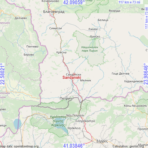
Sandanski GPS coordinates[2]
41° 34' 0.012" North, 23° 16' 59.988" East
| Map corner | latitude | longitude |
|---|---|---|
| Upper-left | 42.09059°, | 22.58021° |
| Center: | 41.56667°, | 23.28333° |
| Lower-right: | 41.03846°, | 23.98646° |
| Map W x H: | 117×117 km | = 72.7×72.7mi |
| max Lat: | 44.16214° ⇑96.3% North |
| Sandanski: | 41.56667° |
| min Lat: | ⇓3.7% South 41.32715° |
| min Long | Sandanski | max Long |
| 22.52139° | 23.28333° | 28.53429° |
| W 16%⇐ | ⇒84% E |
Elevation
Elevation of Sandanski is 246 m = 807 ft, and this is 70.6 m = 232 ft below average elevation for this country.
| Max E: |
1221 m = 4006 ft | 46.3% |
| Avg. | 316.6 m = 1039 ft | |
| Sandanski | 246 m = 807 ft | |
Min E: |
1 m = 3 ft | 53.7% |
See also: Bulgaria elevation on elevation.city.
Geographical zone
Sandanski is located in North temperate zone (between Tropic of Cancer and the Arctic Circle). Distance of this Northern Tropic circle is 2015.9 km =1252.6 mi to South.| Distance of | km | miles | from Sandanski |
|---|---|---|---|
| North Pole | 5385.3 | 3346.3 | to North |
| Arctic Circle | 2779.4 | 1727 | to North |
| Tropic Cancer | 2015.9 | 1252.6 | to South |
| Equator | 4621.8 | 2871.9 | to South |


Nearby cities:
15 places around Sandanski: (largest is in red/bold)
• Bansko
34.7 km =21.6 mi,  29°
29°
• Belitsa
49.6 km =30.8 mi, 28°
• Blagoevgrad
52.3 km =32.5 mi,  343°
343°
• Garmen
44.5 km =27.7 mi,  85°
85°
• Gotse Delchev
37.4 km =23.2 mi, 90°
• Hadzhidimovo
49 km =30.4 mi,  95°
95°
• Kolarovo
26.9 km =16.7 mi,  213°
213°
• Kresna
21.6 km =13.4 mi,  329°
329°
• Petrich
19.8 km =12.3 mi,  198°
198°
• Porominovo
59 km =36.7 mi, 343°
• Razlog
38.7 km =24 mi,  23°
23°
• Satovcha
58.5 km =36.4 mi,  84°
84°
• Simitli
37.8 km =23.5 mi, 338°
• Stara Kresna
27.2 km =16.9 mi, 342°
• Strumyani
10.1 km =6.3 mi,  316°
316°
Sources, notices
• [Note1] Compared only with cities in Bulgaria existing in our database
• [Src1] Map data: © OpenStreetMap contributors (CC-BY-SA)
• [Src2] Other city data from geonames.org with taken over terms of usage.
• [Src3] Geographical zone / Annual Mean Temperature by Robert A. Rohde @ Wikipedia
