Ravda geodata
Ravda (Burgas) is a populated place; located in Bulgaria in Europe/Sofia (GMT+3) time zone. With population of 2,556 people, there are 212 cities with bigger population in this country. Compared to other cities in Bulgaria, 60% of cities are located further ↑North; 91.7% of cities are located further ←West and 99% of cities have higher elevation than Ravda. Note1


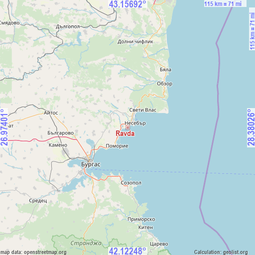
Ravda GPS coordinates[2]
42° 38' 30.66" North, 27° 40' 37.668" East
| Map corner | latitude | longitude |
|---|---|---|
| Upper-left | 43.15692°, | 26.97401° |
| Center: | 42.64185°, | 27.67713° |
| Lower-right: | 42.12248°, | 28.38026° |
| Map W x H: | 115×115 km | = 71.5×71.5mi |
| max Lat: | 44.16214° ⇑60% North |
| Ravda: | 42.64185° |
| min Lat: | ⇓40% South 41.32715° |
| min Long | Ravda | max Long |
| 22.52139° | 27.67713° | 28.53429° |
| W 91.7%⇐ | ⇒8.3% E |
Elevation
Elevation of Ravda is 13 m = 43 ft, and this is 303.6 m = 996 ft below average elevation for this country.
| Max E: |
1221 m = 4006 ft | 99% |
| Avg. | 316.6 m = 1039 ft | |
| Ravda | 13 m = 43 ft | |
Min E: |
1 m = 3 ft | 1% |
See also: Bulgaria elevation on elevation.city.
Geographical zone
Ravda is located in North temperate zone (between Tropic of Cancer and the Arctic Circle). Distance of this Northern Tropic circle is 2135.4 km =1326.9 mi to South.| Distance of | km | miles | from Ravda |
|---|---|---|---|
| North Pole | 5265.7 | 3272 | to North |
| Arctic Circle | 2659.8 | 1652.7 | to North |
| Tropic Cancer | 2135.4 | 1326.9 | to South |
| Equator | 4741.3 | 2946.1 | to South |


Nearby cities:
15 places around Ravda: (largest is in red/bold)
• Aheloy
2.5 km =1.6 mi,  290°
290°
• Aytos
35.5 km =22.1 mi,  280°
280°
• Bata
18.2 km =11.3 mi,  305°
305°
• Burgas
22.8 km =14.2 mi,  228°
228°
• Byala
31.1 km =19.3 mi,  33°
33°
• Chernomorets
22.2 km =13.8 mi,  188°
188°
• Dolni Chiflik
39.2 km =24.4 mi,  4°
4°
• Kameno
32 km =19.9 mi,  255°
255°
• Nesebar
5.2 km =3.2 mi,  68°
68°
• Obzor
25.8 km =16 mi,  39°
39°
• Pomorie
9.6 km =6 mi,  203°
203°
• Ruen
36.7 km =22.8 mi,  298°
298°
• Sarafovo
15.6 km =9.7 mi, 234°
• Sozopol
24.9 km =15.5 mi,  176°
176°
• Sveti Vlas
10.4 km =6.5 mi, 39°
Sources, notices
• [Note1] Compared only with cities in Bulgaria existing in our database
• [Src1] Map data: © OpenStreetMap contributors (CC-BY-SA)
• [Src2] Other city data from geonames.org with taken over terms of usage.
• [Src3] Geographical zone / Annual Mean Temperature by Robert A. Rohde @ Wikipedia
