Aytos geodata
Aytos (Burgas) is a populated place; located in Bulgaria in Europe/Sofia (GMT+3) time zone. With population of 20,986 people, there are 42 cities with bigger population in this country. Compared to other cities in Bulgaria, 56.3% of cities are located further ↑North; 84.3% of cities are located further ←West and 82% of cities have higher elevation than Aytos. Note1


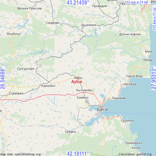
Aytos GPS coordinates[2]
42° 42' 0" North, 27° 15' 0" East
| Map corner | latitude | longitude |
|---|---|---|
| Upper-left | 43.21459°, | 26.54688° |
| Center: | 42.7°, | 27.25° |
| Lower-right: | 42.18111°, | 27.95313° |
| Map W x H: | 114.9×114.9 km | = 71.4×71.4mi |
| max Lat: | 44.16214° ⇑56.3% North |
| Aytos: | 42.7° |
| min Lat: | ⇓43.7% South 41.32715° |
| min Long | Aytos | max Long |
| 22.52139° | 27.25° | 28.53429° |
| W 84.3%⇐ | ⇒15.7% E |
Elevation
Elevation of Aytos is 89 m = 292 ft, and this is 227.6 m = 747 ft below average elevation for this country.
| Max E: |
1221 m = 4006 ft | 82% |
| Avg. | 316.6 m = 1039 ft | |
| Aytos | 89 m = 292 ft | |
Min E: |
1 m = 3 ft | 18% |
See also: Bulgaria elevation on elevation.city.
Geographical zone
Aytos is located in North temperate zone (between Tropic of Cancer and the Arctic Circle). Distance of this Northern Tropic circle is 2141.9 km =1330.9 mi to South.| Distance of | km | miles | from Aytos |
|---|---|---|---|
| North Pole | 5259.3 | 3268 | to North |
| Arctic Circle | 2653.4 | 1648.7 | to North |
| Tropic Cancer | 2141.9 | 1330.9 | to South |
| Equator | 4747.8 | 2950.1 | to South |


Nearby cities:
15 places around Aytos: (largest is in red/bold)
• Aheloy
33 km =20.5 mi,  99°
99°
• Bata
20.6 km =12.8 mi,  78°
78°
• Burgas
28 km =17.4 mi,  140°
140°
• Chernomorets
42.7 km =26.5 mi,  131°
131°
• Dalgopol
39.8 km =24.7 mi,  11°
11°
• Kameno
14.9 km =9.3 mi,  164°
164°
• Karnobat
22.5 km =14 mi,  255°
255°
• Nesebar
40 km =24.9 mi, 96°
• Pomorie
34.6 km =21.5 mi,  116°
116°
• Ravda
35.5 km =22.1 mi, 100°
• Ruen
11.4 km =7.1 mi, 13°
• Sarafovo
27.1 km =16.8 mi, 124°
• Sredets
39.6 km =24.6 mi,  188°
188°
• Sungurlare
38.8 km =24.1 mi,  281°
281°
• Sveti Vlas
41.6 km =25.8 mi,  87°
87°
Sources, notices
• [Note1] Compared only with cities in Bulgaria existing in our database
• [Src1] Map data: © OpenStreetMap contributors (CC-BY-SA)
• [Src2] Other city data from geonames.org with taken over terms of usage.
• [Src3] Geographical zone / Annual Mean Temperature by Robert A. Rohde @ Wikipedia
