Bata geodata
Bata (Burgas) is a populated place; located in Bulgaria in Europe/Sofia (GMT+3) time zone. With population of 1,235 people, there are 263 cities with bigger population in this country. Compared to other cities in Bulgaria, 53.3% of cities are located further ↑North; 88% of cities are located further ←West and 54.3% of cities have higher elevation than Bata. Note1


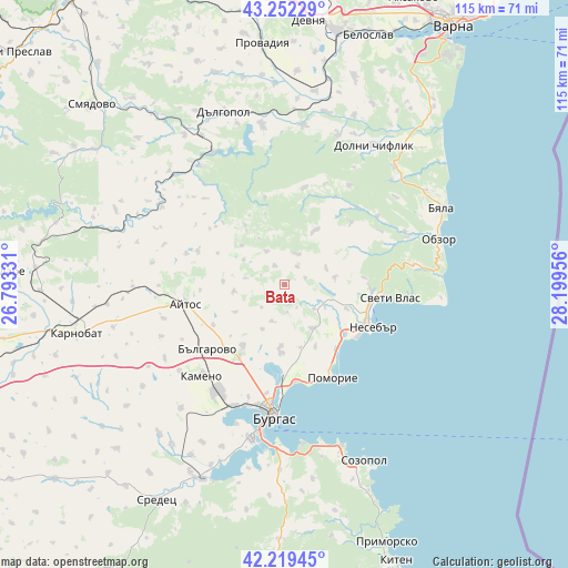
Bata GPS coordinates[2]
42° 44' 16.872" North, 27° 29' 47.148" East
| Map corner | latitude | longitude |
|---|---|---|
| Upper-left | 43.25229°, | 26.79331° |
| Center: | 42.73802°, | 27.49643° |
| Lower-right: | 42.21945°, | 28.19956° |
| Map W x H: | 114.8×114.8 km | = 71.3×71.3mi |
| max Lat: | 44.16214° ⇑53.3% North |
| Bata: | 42.73802° |
| min Lat: | ⇓46.7% South 41.32715° |
| min Long | Bata | max Long |
| 22.52139° | 27.49643° | 28.53429° |
| W 88%⇐ | ⇒12% E |
Elevation
Elevation of Bata is 206 m = 676 ft, and this is 110.6 m = 363 ft below average elevation for this country.
| Max E: |
1221 m = 4006 ft | 54.3% |
| Avg. | 316.6 m = 1039 ft | |
| Bata | 206 m = 676 ft | |
Min E: |
1 m = 3 ft | 45.7% |
See also: Bulgaria elevation on elevation.city.
Geographical zone
Bata is located in North temperate zone (between Tropic of Cancer and the Arctic Circle). Distance of this Northern Tropic circle is 2146.1 km =1333.5 mi to South.| Distance of | km | miles | from Bata |
|---|---|---|---|
| North Pole | 5255 | 3265.3 | to North |
| Arctic Circle | 2649.2 | 1646.1 | to North |
| Tropic Cancer | 2146.1 | 1333.5 | to South |
| Equator | 4752 | 2952.8 | to South |


Nearby cities:
15 places around Bata: (largest is in red/bold)
• Aheloy
15.8 km =9.8 mi,  128°
128°
• Aytos
20.6 km =12.8 mi,  258°
258°
• Burgas
25.9 km =16.1 mi,  185°
185°
• Byala
35.4 km =22 mi,  64°
64°
• Chernomorets
34.7 km =21.6 mi,  160°
160°
• Dalgopol
36.7 km =22.8 mi,  341°
341°
• Dolni Chiflik
33.5 km =20.8 mi,  32°
32°
• Kameno
24.6 km =15.3 mi,  221°
221°
• Nesebar
21.5 km =13.4 mi,  114°
114°
• Obzor
32.6 km =20.3 mi,  73°
73°
• Pomorie
22.3 km =13.9 mi,  150°
150°
• Ravda
18.2 km =11.3 mi, 125°
• Ruen
18.7 km =11.6 mi,  291°
291°
• Sarafovo
19.8 km =12.3 mi,  173°
173°
• Sveti Vlas
21.6 km =13.4 mi,  97°
97°
Sources, notices
• [Note1] Compared only with cities in Bulgaria existing in our database
• [Src1] Map data: © OpenStreetMap contributors (CC-BY-SA)
• [Src2] Other city data from geonames.org with taken over terms of usage.
• [Src3] Geographical zone / Annual Mean Temperature by Robert A. Rohde @ Wikipedia
