Sozopol geodata
Sozopol (Burgas) is a seat of a second-order administrative division; located in Bulgaria in Europe/Sofia (GMT+3) time zone. With population of 4,500 people, there are 145 cities with bigger population in this country. Compared to other cities in Bulgaria, 68.7% of cities are located further ↑North; 92% of cities are located further ←West and 98% of cities have higher elevation than Sozopol. Note1


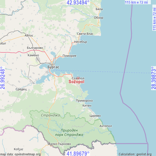
Sozopol GPS coordinates[2]
42° 25' 4.836" North, 27° 41' 44.16" East
| Map corner | latitude | longitude |
|---|---|---|
| Upper-left | 42.93494°, | 26.99248° |
| Center: | 42.41801°, | 27.6956° |
| Lower-right: | 41.89679°, | 28.39873° |
| Map W x H: | 115.4×115.4 km | = 71.7×71.7mi |
| max Lat: | 44.16214° ⇑68.7% North |
| Sozopol: | 42.41801° |
| min Lat: | ⇓31.3% South 41.32715° |
| min Long | Sozopol | max Long |
| 22.52139° | 27.6956° | 28.53429° |
| W 92%⇐ | ⇒8% E |
Elevation
Elevation of Sozopol is 20 m = 66 ft, and this is 296.6 m = 973 ft below average elevation for this country.
| Max E: |
1221 m = 4006 ft | 98% |
| Avg. | 316.6 m = 1039 ft | |
| Sozopol | 20 m = 66 ft | |
Min E: |
1 m = 3 ft | 2% |
See also: Bulgaria elevation on elevation.city.
Geographical zone
Sozopol is located in North temperate zone (between Tropic of Cancer and the Arctic Circle). Distance of this Northern Tropic circle is 2110.5 km =1311.4 mi to South.| Distance of | km | miles | from Sozopol |
|---|---|---|---|
| North Pole | 5290.6 | 3287.4 | to North |
| Arctic Circle | 2684.7 | 1668.2 | to North |
| Tropic Cancer | 2110.5 | 1311.4 | to South |
| Equator | 4716.4 | 2930.6 | to South |


Nearby cities:
15 places around Sozopol: (largest is in red/bold)
• Aheloy
26.1 km =16.2 mi,  351°
351°
• Ahtopol
40.9 km =25.4 mi,  150°
150°
• Bata
39.1 km =24.3 mi,  335°
335°
• Burgas
21.1 km =13.1 mi,  297°
297°
• Chernomorets
5.5 km =3.4 mi, 301°
• Kameno
36.7 km =22.8 mi, 297°
• Kiten
21.4 km =13.3 mi,  162°
162°
• Nesebar
27 km =16.8 mi,  7°
7°
• Pomorie
17 km =10.6 mi, 341°
• Primorsko
17.4 km =10.8 mi, 163°
• Ravda
24.9 km =15.5 mi,  356°
356°
• Sarafovo
21.3 km =13.2 mi,  318°
318°
• Sredets
43.1 km =26.8 mi,  259°
259°
• Sveti Vlas
33.3 km =20.7 mi, 8°
• Tsarevo
30.2 km =18.8 mi, 155°
Sources, notices
• [Note1] Compared only with cities in Bulgaria existing in our database
• [Src1] Map data: © OpenStreetMap contributors (CC-BY-SA)
• [Src2] Other city data from geonames.org with taken over terms of usage.
• [Src3] Geographical zone / Annual Mean Temperature by Robert A. Rohde @ Wikipedia
