Kameno geodata
Kameno (Burgas) is a populated place; located in Bulgaria in Europe/Sofia (GMT+3) time zone. With population of 4,952 people, there are 138 cities with bigger population in this country. Compared to other cities in Bulgaria, 63.7% of cities are located further ↑North; 85.7% of cities are located further ←West and 98% of cities have higher elevation than Kameno. Note1


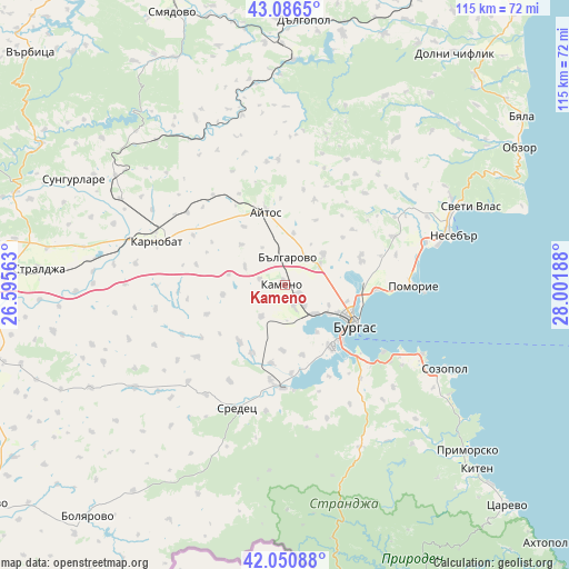
Kameno GPS coordinates[2]
42° 34' 15.024" North, 27° 17' 55.5" East
| Map corner | latitude | longitude |
|---|---|---|
| Upper-left | 43.0865°, | 26.59563° |
| Center: | 42.57084°, | 27.29875° |
| Lower-right: | 42.05088°, | 28.00188° |
| Map W x H: | 115.2×115.1 km | = 71.6×71.5mi |
| max Lat: | 44.16214° ⇑63.7% North |
| Kameno: | 42.57084° |
| min Lat: | ⇓36.3% South 41.32715° |
| min Long | Kameno | max Long |
| 22.52139° | 27.29875° | 28.53429° |
| W 85.7%⇐ | ⇒14.3% E |
Elevation
Elevation of Kameno is 20 m = 66 ft, and this is 296.6 m = 973 ft below average elevation for this country.
| Max E: |
1221 m = 4006 ft | 98% |
| Avg. | 316.6 m = 1039 ft | |
| Kameno | 20 m = 66 ft | |
Min E: |
1 m = 3 ft | 2% |
See also: Bulgaria elevation on elevation.city.
Geographical zone
Kameno is located in North temperate zone (between Tropic of Cancer and the Arctic Circle). Distance of this Northern Tropic circle is 2127.5 km =1322 mi to South.| Distance of | km | miles | from Kameno |
|---|---|---|---|
| North Pole | 5273.6 | 3276.9 | to North |
| Arctic Circle | 2667.7 | 1657.6 | to North |
| Tropic Cancer | 2127.5 | 1322 | to South |
| Equator | 4733.4 | 2941.2 | to South |


Nearby cities:
15 places around Kameno: (largest is in red/bold)
• Aheloy
29.9 km =18.6 mi,  72°
72°
• Aytos
14.9 km =9.3 mi,  344°
344°
• Bata
24.6 km =15.3 mi,  41°
41°
• Burgas
15.6 km =9.7 mi,  117°
117°
• Chernomorets
31.3 km =19.4 mi, 116°
• Karnobat
27.3 km =17 mi,  288°
288°
• Nesebar
37.1 km =23.1 mi, 74°
• Pomorie
27.1 km =16.8 mi,  91°
91°
• Ravda
32 km =19.9 mi,  75°
75°
• Ruen
25.5 km =15.8 mi,  357°
357°
• Sarafovo
18.3 km =11.4 mi, 93°
• Sozopol
36.7 km =22.8 mi, 117°
• Sredets
26.7 km =16.6 mi,  201°
201°
• Sungurlare
47.4 km =29.5 mi,  297°
297°
• Sveti Vlas
40.8 km =25.4 mi, 67°
Sources, notices
• [Note1] Compared only with cities in Bulgaria existing in our database
• [Src1] Map data: © OpenStreetMap contributors (CC-BY-SA)
• [Src2] Other city data from geonames.org with taken over terms of usage.
• [Src3] Geographical zone / Annual Mean Temperature by Robert A. Rohde @ Wikipedia
