Burgas geodata
Burgas is a seat of a first-order administrative division; located in Bulgaria in Europe/Sofia (GMT+3) time zone. With population of 195,966 people, there are 3 cities with bigger population in this country. Compared to other cities in Bulgaria, 65% of cities are located further ↑North; 87.7% of cities are located further ←West and 90.7% of cities have higher elevation than Burgas. Note1


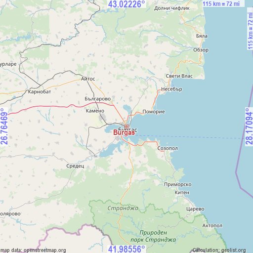
Burgas GPS coordinates[2]
42° 30' 21.816" North, 27° 28' 4.116" East
| Map corner | latitude | longitude |
|---|---|---|
| Upper-left | 43.02226°, | 26.76469° |
| Center: | 42.50606°, | 27.46781° |
| Lower-right: | 41.98556°, | 28.17094° |
| Map W x H: | 115.3×115.3 km | = 71.6×71.6mi |
| max Lat: | 44.16214° ⇑65% North |
| Burgas: | 42.50606° |
| min Lat: | ⇓35% South 41.32715° |
| min Long | Burgas | max Long |
| 22.52139° | 27.46781° | 28.53429° |
| W 87.7%⇐ | ⇒12.3% E |
Elevation
Elevation of Burgas is 36 m = 118 ft, and this is 280.6 m = 921 ft below average elevation for this country.
| Max E: |
1221 m = 4006 ft | 90.7% |
| Avg. | 316.6 m = 1039 ft | |
| Burgas | 36 m = 118 ft | |
Min E: |
1 m = 3 ft | 9.3% |
See also: Burgas elevation on elevation.city.
Geographical zone
Burgas is located in North temperate zone (between Tropic of Cancer and the Arctic Circle). Distance of this Northern Tropic circle is 2120.3 km =1317.5 mi to South.| Distance of | km | miles | from Burgas |
|---|---|---|---|
| North Pole | 5280.8 | 3281.3 | to North |
| Arctic Circle | 2674.9 | 1662.1 | to North |
| Tropic Cancer | 2120.3 | 1317.5 | to South |
| Equator | 4726.2 | 2936.7 | to South |


Nearby cities:
15 places around Burgas: (largest is in red/bold)
• Aheloy
21.8 km =13.5 mi,  42°
42°
• Aytos
28 km =17.4 mi,  320°
320°
• Bata
25.9 km =16.1 mi,  5°
5°
• Chernomorets
15.6 km =9.7 mi,  116°
116°
• Kameno
15.6 km =9.7 mi,  297°
297°
• Kiten
39.4 km =24.5 mi,  140°
140°
• Nesebar
27.8 km =17.3 mi,  52°
52°
• Pomorie
14.7 km =9.1 mi,  64°
64°
• Primorsko
35.5 km =22.1 mi, 138°
• Ravda
22.8 km =14.2 mi, 48°
• Ruen
36 km =22.4 mi,  335°
335°
• Sarafovo
7.5 km =4.7 mi, 36°
• Sozopol
21.1 km =13.1 mi, 117°
• Sredets
29.5 km =18.3 mi,  233°
233°
• Sveti Vlas
33.2 km =20.6 mi, 45°
Sources, notices
• [Note1] Compared only with cities in Bulgaria existing in our database
• [Src1] Map data: © OpenStreetMap contributors (CC-BY-SA)
• [Src2] Other city data from geonames.org with taken over terms of usage.
• [Src3] Geographical zone / Annual Mean Temperature by Robert A. Rohde @ Wikipedia
