Nikolaevo geodata
Nikolaevo (Stara Zagora) is a populated place; located in Bulgaria in Europe/Sofia (GMT+3) time zone. With population of 3,160 people, there are 190 cities with bigger population in this country. Compared to other cities in Bulgaria, 61% of cities are located further ↑North; 63.3% of cities are located further ←West and 57.7% of cities have lower elevation than Nikolaevo. Note1


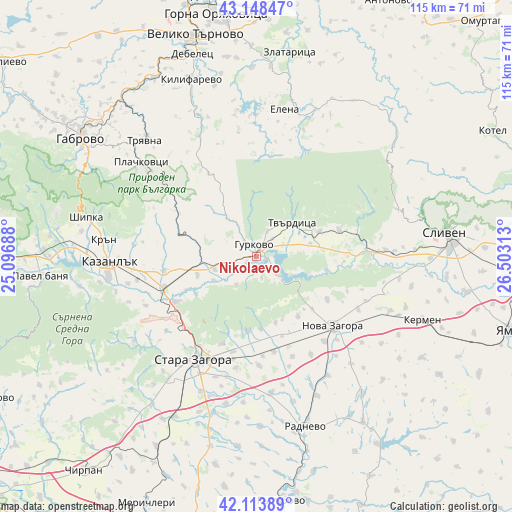
Nikolaevo GPS coordinates[2]
42° 37' 59.988" North, 25° 48' 0" East
| Map corner | latitude | longitude |
|---|---|---|
| Upper-left | 43.14847°, | 25.09688° |
| Center: | 42.63333°, | 25.8° |
| Lower-right: | 42.11389°, | 26.50313° |
| Map W x H: | 115×115 km | = 71.5×71.5mi |
| max Lat: | 44.16214° ⇑61% North |
| Nikolaevo: | 42.63333° |
| min Lat: | ⇓39% South 41.32715° |
| min Long | Nikolaevo | max Long |
| 22.52139° | 25.8° | 28.53429° |
| W 63.3%⇐ | ⇒36.7% E |
Elevation
Elevation of Nikolaevo is 277 m = 909 ft, and this is 39.6 m = 130 ft below average elevation for this country.
| Max E: |
1221 m = 4006 ft | 42.3% |
| Avg. | 316.6 m = 1039 ft | |
| Nikolaevo | 277 m = 909 ft | |
Min E: |
1 m = 3 ft | 57.7% |
See also: Bulgaria elevation on elevation.city.
Geographical zone
Nikolaevo is located in North temperate zone (between Tropic of Cancer and the Arctic Circle). Distance of this Northern Tropic circle is 2134.5 km =1326.3 mi to South.| Distance of | km | miles | from Nikolaevo |
|---|---|---|---|
| North Pole | 5266.7 | 3272.6 | to North |
| Arctic Circle | 2660.8 | 1653.3 | to North |
| Tropic Cancer | 2134.5 | 1326.3 | to South |
| Equator | 4740.4 | 2945.5 | to South |


Nearby cities:
15 places around Nikolaevo: (largest is in red/bold)
• Elena
34 km =21.1 mi,  11°
11°
• Elkhovo
40.9 km =25.4 mi,  227°
227°
• Gabrovo
46.5 km =28.9 mi,  305°
305°
• Gurkovo
3.7 km =2.3 mi,  0°
0°
• Kazanlak
32.8 km =20.4 mi,  266°
266°
• Kermen
39.7 km =24.7 mi,  111°
111°
• Kilifarevo
41.2 km =25.6 mi,  340°
340°
• Maglizh
20.8 km =12.9 mi,  259°
259°
• Nova Zagora
24.4 km =15.2 mi,  133°
133°
• Radnevo
38.6 km =24 mi,  163°
163°
• Shipka
39.3 km =24.4 mi,  283°
283°
• Sliven
43.7 km =27.2 mi,  82°
82°
• Stara Zagora
25.8 km =16 mi,  210°
210°
• Tryavna
35.7 km =22.2 mi,  316°
316°
• Tvarditsa
11 km =6.8 mi,  47°
47°
Sources, notices
• [Note1] Compared only with cities in Bulgaria existing in our database
• [Src1] Map data: © OpenStreetMap contributors (CC-BY-SA)
• [Src2] Other city data from geonames.org with taken over terms of usage.
• [Src3] Geographical zone / Annual Mean Temperature by Robert A. Rohde @ Wikipedia
