Gurkovo geodata
Gurkovo (Stara Zagora) is a populated place; located in Bulgaria in Europe/Sofia (GMT+3) time zone. With population of 2,889 people, there are 201 cities with bigger population in this country. Compared to other cities in Bulgaria, 58% of cities are located further ↑North; 63.3% of cities are located further ←West and 68.3% of cities have lower elevation than Gurkovo. Note1


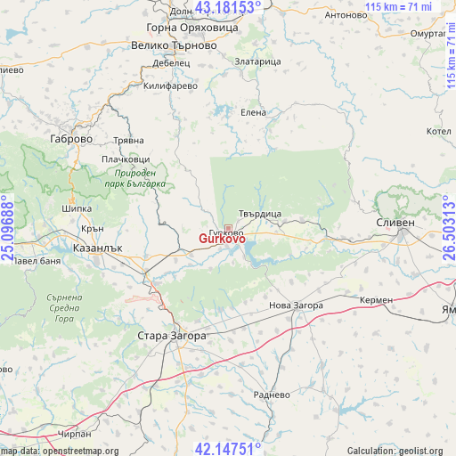
Gurkovo GPS coordinates[2]
42° 40' 0.012" North, 25° 48' 0" East
| Map corner | latitude | longitude |
|---|---|---|
| Upper-left | 43.18153°, | 25.09688° |
| Center: | 42.66667°, | 25.8° |
| Lower-right: | 42.14751°, | 26.50313° |
| Map W x H: | 115×115 km | = 71.5×71.5mi |
| max Lat: | 44.16214° ⇑58% North |
| Gurkovo: | 42.66667° |
| min Lat: | ⇓42% South 41.32715° |
| min Long | Gurkovo | max Long |
| 22.52139° | 25.8° | 28.53429° |
| W 63.3%⇐ | ⇒36.7% E |
Elevation
Elevation of Gurkovo is 375 m = 1230 ft, and this is 58.4 m = 192 ft above average elevation for this country.
| Max E: |
1221 m = 4006 ft | 31.7% |
| Gurkovo | 375 m 1230 ft | |
| Avg. | 316.6 m = 1039 ft | |
Min E: |
1 m = 3 ft | 68.3% |
See also: Bulgaria elevation on elevation.city.
Geographical zone
Gurkovo is located in North temperate zone (between Tropic of Cancer and the Arctic Circle). Distance of this Northern Tropic circle is 2138.2 km =1328.6 mi to South.| Distance of | km | miles | from Gurkovo |
|---|---|---|---|
| North Pole | 5263 | 3270.3 | to North |
| Arctic Circle | 2657.1 | 1651 | to North |
| Tropic Cancer | 2138.2 | 1328.6 | to South |
| Equator | 4744.1 | 2947.8 | to South |


Nearby cities:
15 places around Gurkovo: (largest is in red/bold)
• Debelets
43.4 km =27 mi,  339°
339°
• Elena
30.4 km =18.9 mi,  12°
12°
• Kazanlak
33.2 km =20.6 mi,  260°
260°
• Kermen
41.2 km =25.6 mi,  116°
116°
• Kilifarevo
37.7 km =23.4 mi, 338°
• Maglizh
21.8 km =13.5 mi,  250°
250°
• Nikolaevo
3.7 km =2.3 mi,  180°
180°
• Nova Zagora
27 km =16.8 mi,  138°
138°
• Radnevo
42.2 km =26.2 mi,  164°
164°
• Shipka
38.5 km =23.9 mi,  278°
278°
• Sliven
43.3 km =26.9 mi,  87°
87°
• Stara Zagora
29.1 km =18.1 mi,  206°
206°
• Tryavna
33.1 km =20.6 mi,  312°
312°
• Tvarditsa
9 km =5.6 mi,  65°
65°
• Zlataritsa
43.4 km =27 mi, 10°
Sources, notices
• [Note1] Compared only with cities in Bulgaria existing in our database
• [Src1] Map data: © OpenStreetMap contributors (CC-BY-SA)
• [Src2] Other city data from geonames.org with taken over terms of usage.
• [Src3] Geographical zone / Annual Mean Temperature by Robert A. Rohde @ Wikipedia
