Lokossa geodata
Lokossa (Mono) is a seat of a first-order administrative division; located in Benin in Africa/Porto-Novo (GMT+1) time zone. With population of 86,971 people, there are 7 cities with bigger population in this country. Compared to other cities in Benin, 76.1% of cities are located further ↑North; 89.1% of cities are located further →East and 71.7% of cities have higher elevation than Lokossa. Note1


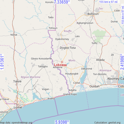
Lokossa GPS coordinates[2]
6° 38' 19.284" North, 1° 43' 0.264" East
| Map corner | latitude | longitude |
|---|---|---|
| Upper-left | 7.33659°, | 1.01361° |
| Center: | 6.63869°, | 1.71674° |
| Lower-right: | 5.9398°, | 2.41986° |
| Map W x H: | 155.3×155.3 km | = 96.5×96.5mi |
| max Lat: | 11.86819° ⇑76.1% North |
| Lokossa: | 6.63869° |
| min Lat: | ⇓23.9% South 6.28036° |
| min Long | Lokossa | max Long |
| 1.26651° | 1.71674° | 3.38327° |
| W 10.9%⇐ | ⇒89.1% E |
Elevation
Elevation of Lokossa is 47 m = 154 ft, and this is 115.8 m = 380 ft below average elevation for this country.
| Max E: |
472 m = 1549 ft | 71.7% |
| Avg. | 162.8 m = 534 ft | |
| Lokossa | 47 m = 154 ft | |
Min E: |
1 m = 3 ft | 28.3% |
See also: Lokossa elevation on elevation.city.
Geographical zone
Lokossa is located in North Torrid zone (between Equator and Tropic of Cancer). Distance of Equator is 738.2 km =458.7 mi to South.| Distance of | km | miles | from Lokossa |
|---|---|---|---|
| North Pole | 9268.9 | 5759.4 | to North |
| Arctic Circle | 6663 | 4140.2 | to North |
| Tropic Cancer | 1867.8 | 1160.6 | to North |
| Equator | 738.2 | 458.7 | to South |


Nearby cities:
15 places around Lokossa: (largest is in red/bold)
• Abomey
67.7 km =42.1 mi,  26°
26°
• Abomey-Calavi
73.7 km =45.8 mi,  106°
106°
• Allada
48.1 km =29.9 mi,  86°
86°
• Aplahoué
33 km =20.5 mi,  353°
353°
• Avakpa
36.1 km =22.4 mi, 85°
• Bohicon
71.4 km =44.4 mi, 32°
• Comé
31.5 km =19.6 mi,  144°
144°
• Dogbo
19.2 km =11.9 mi,  21°
21°
• Grand-Popo
41.5 km =25.8 mi,  163°
163°
• Hinvi
51.7 km =32.1 mi,  74°
74°
• Hévié
63.9 km =39.7 mi, 112°
• Kpomassè
36.3 km =22.6 mi,  122°
122°
• Ouidah
50.9 km =31.6 mi,  126°
126°
• Pahou
61.6 km =38.3 mi, 116°
• Sé
44.6 km =27.7 mi, 73°
Sources, notices
• [Note1] Compared only with cities in Benin existing in our database
• [Src1] Map data: © OpenStreetMap contributors (CC-BY-SA)
• [Src2] Other city data from geonames.org with taken over terms of usage.
• [Src3] Geographical zone / Annual Mean Temperature by Robert A. Rohde @ Wikipedia
