Aplahoué geodata
Aplahoué (Kouffo) is a populated place; located in Benin in Africa/Porto-Novo (GMT+1) time zone. With population of 19,862 people, there are 27 cities with bigger population in this country. Compared to other cities in Benin, 54.3% of cities are located further ↑North; 91.3% of cities are located further →East and 54.3% of cities have lower elevation than Aplahoué. Note1


Aplahoué GPS coordinates[2]
6° 55' 59.988" North, 1° 40' 59.988" East
| Map corner | latitude | longitude |
|---|---|---|
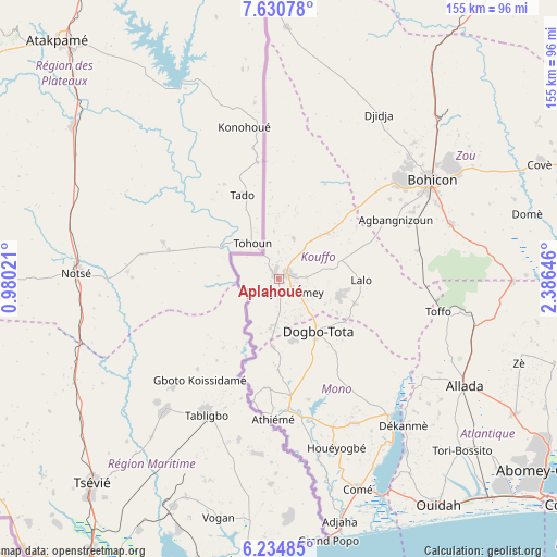
| Upper-left | 7.63078°, | 0.98021° |
| Center: | 6.93333°, | 1.68333° |
| Lower-right: | 6.23485°, | 2.38646° |
| Map W x H: | 155.2×155.2 km | = 96.4×96.4mi |
| max Lat: | 11.86819° ⇑54.3% North |
| Aplahoué: | 6.93333° |
| min Lat: | ⇓45.7% South 6.28036° |
| min Long | Aplahoué | max Long |
| 1.26651° | 1.68333° | 3.38327° |
| W 8.7%⇐ | ⇒91.3% E |
Elevation
Elevation of Aplahoué is 124 m = 407 ft, and this is 38.8 m = 127 ft below average elevation for this country.
| Max E: |
472 m = 1549 ft | 45.7% |
| Avg. | 162.8 m = 534 ft | |
| Aplahoué | 124 m = 407 ft | |
Min E: |
1 m = 3 ft | 54.3% |
See also: Benin elevation on elevation.city.
Geographical zone
Aplahoué is located in North Torrid zone (between Equator and Tropic of Cancer). Distance of Equator is 770.9 km =479 mi to South.| Distance of | km | miles | from Aplahoué |
|---|---|---|---|
| North Pole | 9236.1 | 5739 | to North |
| Arctic Circle | 6630.3 | 4119.9 | to North |
| Tropic Cancer | 1835 | 1140.2 | to North |
| Equator | 770.9 | 479 | to South |


Nearby cities:
15 places around Aplahoué: (largest is in red/bold)
• Abomey
43.9 km =27.3 mi,  50°
50°
• Allada
59.6 km =37 mi,  119°
119°
• Avakpa
49.8 km =30.9 mi,  127°
127°
• Bohicon
50.3 km =31.3 mi,  57°
57°
• Comé
62.4 km =38.8 mi,  159°
159°
• Cové
79.2 km =49.2 mi,  66°
66°
• Dogbo
18.4 km =11.4 mi,  144°
144°
• Grand-Popo
74.2 km =46.1 mi,  168°
168°
• Hinvi
56.5 km =35.1 mi,  109°
109°
• Kpomassè
62.6 km =38.9 mi,  146°
146°
• Lokossa
33 km =20.5 mi, 173°
• Ouidah
77.4 km =48.1 mi, 145°
• Pahou
84.4 km =52.4 mi, 135°
• Sé
50.5 km =31.4 mi, 113°
• Zagnanado
83.6 km =51.9 mi, 67°
Sources, notices
• [Note1] Compared only with cities in Benin existing in our database
• [Src1] Map data: © OpenStreetMap contributors (CC-BY-SA)
• [Src2] Other city data from geonames.org with taken over terms of usage.
• [Src3] Geographical zone / Annual Mean Temperature by Robert A. Rohde @ Wikipedia
