Potosí geodata
Potosí is a seat of a first-order administrative division; located in Bolivia in America/La_Paz (GMT-4) time zone. With population of 141,251 people, there are 6 cities with bigger population in this country. Compared to other cities in Bolivia, 78.9% of cities are located further ↑North; 62.7% of cities are located further →East and 96.9% of cities have lower elevation than Potosí. Note1


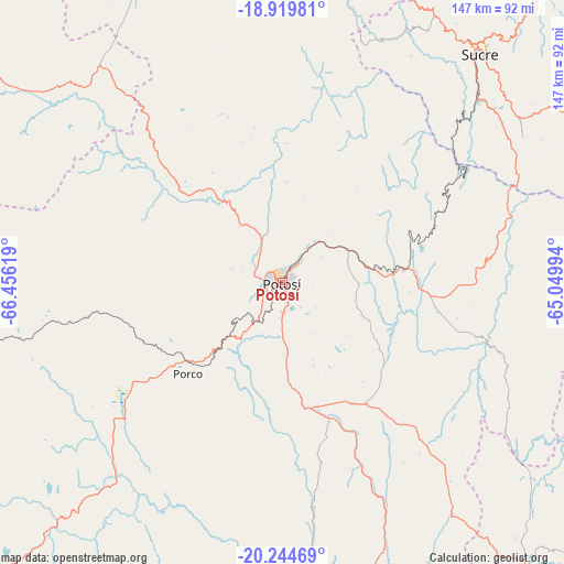
Potosí GPS coordinates[2]
19° 35' 0.996" South, 65° 45' 11.016" West
| Map corner | latitude | longitude |
|---|---|---|
| Upper-left | -18.91981°, | -66.45619° |
| Center: | -19.58361°, | -65.75306° |
| Lower-right: | -20.24469°, | -65.04994° |
| Map W x H: | 147.3×147.3 km | = 91.5×91.5mi |
| max Lat: | -9.71828° ⇑78.9% North |
| Potosí: | -19.58361° |
| min Lat: | ⇓21.1% South -22.73206° |
| min Long | Potosí | max Long |
| -69.14843° | -65.75306° | -57.76667° |
| W 37.3%⇐ | ⇒62.7% E |
Elevation
Elevation of Potosí is 3967 m = 13015 ft, and this is 1955.7 m = 6416 ft above average elevation for this country.
| Max E: |
4732 m = 15525 ft | 3.1% |
| Potosí | 3967 m 13015 ft | |
| Avg. | 2011.3 m = 6599 ft | |
Min E: |
92 m = 302 ft | 96.9% |
See also: Potosí elevation on elevation.city.
Geographical zone
Potosí is located in South Torrid zone (between Equator and Tropic of Capricorn). Distance of this Southern Tropic circle is 428.4 km =266.2 mi to South.| Distance of | km | miles | from Potosí |
|---|---|---|---|
| Equator | 2177.5 | 1353 | to North |
| Tropic Capricorn | 428.4 | 266.2 | to South |
| Antarctic Circle | 5223.7 | 3245.9 | to South |
| South Pole | 7829.6 | 4865.1 | to South |


Nearby cities:
15 places around Potosí: (largest is in red/bold)
• Betanzos
31.5 km =19.6 mi,  83°
83°
• Chaunaca
69.8 km =43.4 mi,  25°
25°
• Colquechaca
101.7 km =63.2 mi,  344°
344°
• Huata
82.2 km =51.1 mi,  39°
39°
• Huayllas
64.2 km =39.9 mi, 44°
• Maragua
68.8 km =42.8 mi, 29°
• Piocera
99.8 km =62 mi,  21°
21°
• Pocpo
92.8 km =57.7 mi, 25°
• Potolo
68.5 km =42.6 mi, 20°
• Pulqui
68.4 km =42.5 mi,  55°
55°
• Sotomayor
83.5 km =51.9 mi,  71°
71°
• Sucre
79.9 km =49.6 mi, 40°
• Tarabuco
98.6 km =61.3 mi, 63°
• Yamparáez
79.3 km =49.3 mi, 56°
• Yotala
69.7 km =43.3 mi,  47°
47°
Sources, notices
• [Note1] Compared only with cities in Bolivia existing in our database
• [Src1] Map data: © OpenStreetMap contributors (CC-BY-SA)
• [Src2] Other city data from geonames.org with taken over terms of usage.
• [Src3] Geographical zone / Annual Mean Temperature by Robert A. Rohde @ Wikipedia
