Los Negros geodata
Los Negros (Santa Cruz) is a populated place; located in Bolivia in America/La_Paz (GMT-4) time zone. With population of 3,046 people, there are 82 cities with bigger population in this country. Compared to other cities in Bolivia, 55.3% of cities are located further ↓South; 78.9% of cities are located further ←West and 73.3% of cities have higher elevation than Los Negros. Note1


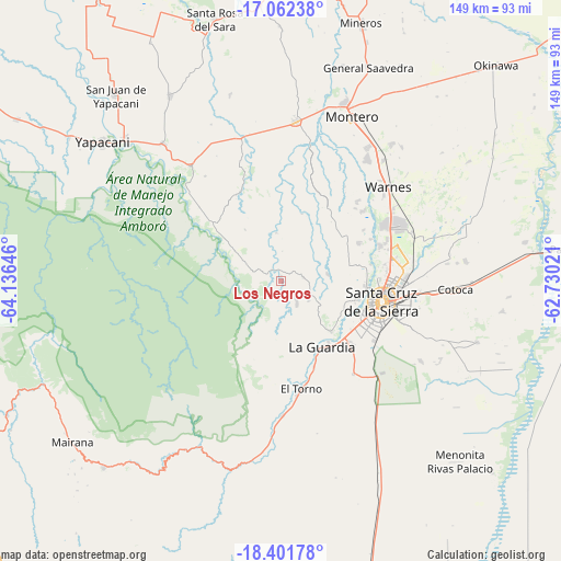
Los Negros GPS coordinates[2]
17° 43' 59.988" South, 63° 25' 59.988" West
| Map corner | latitude | longitude |
|---|---|---|
| Upper-left | -17.06238°, | -64.13646° |
| Center: | -17.73333°, | -63.43333° |
| Lower-right: | -18.40178°, | -62.73021° |
| Map W x H: | 148.9×148.9 km | = 92.5×92.5mi |
| max Lat: | -9.71828° ⇑44.7% North |
| Los Negros: | -17.73333° |
| min Lat: | ⇓55.3% South -22.73206° |
| min Long | Los Negros | max Long |
| -69.14843° | -63.43333° | -57.76667° |
| W 78.9%⇐ | ⇒21.1% E |
Elevation
Elevation of Los Negros is 420 m = 1378 ft, and this is 1591.3 m = 5221 ft below average elevation for this country.
| Max E: |
4732 m = 15525 ft | 73.3% |
| Avg. | 2011.3 m = 6599 ft | |
| Los Negros | 420 m = 1378 ft | |
Min E: |
92 m = 302 ft | 26.7% |
See also: Bolivia elevation on elevation.city.
Geographical zone
Los Negros is located in South Torrid zone (between Equator and Tropic of Capricorn). Distance of this Southern Tropic circle is 634.2 km =394.1 mi to South.| Distance of | km | miles | from Los Negros |
|---|---|---|---|
| Equator | 1971.8 | 1225.2 | to North |
| Tropic Capricorn | 634.2 | 394.1 | to South |
| Antarctic Circle | 5429.4 | 3373.7 | to South |
| South Pole | 8035.3 | 4992.9 | to South |


Nearby cities:
15 places around Los Negros: (largest is in red/bold)
• Buena Vista
39.6 km =24.6 mi,  320°
320°
• Cotoca
41.6 km =25.8 mi,  102°
102°
• Jorochito
35.8 km =22.2 mi,  179°
179°
• La Bélgica
30.7 km =19.1 mi,  48°
48°
• Limoncito
33.2 km =20.6 mi,  174°
174°
• Montero
48 km =29.8 mi,  23°
23°
• Paurito
52.1 km =32.4 mi,  108°
108°
• Portachuelo
42.7 km =26.5 mi,  5°
5°
• San Carlos
50 km =31.1 mi, 317°
• San Juan del Surutú
39.6 km =24.6 mi,  314°
314°
• Santa Cruz de la Sierra
27.3 km =17 mi, 102°
• Santa Fe
46 km =28.6 mi,  115°
115°
• Santa Rita
27.4 km =17 mi,  161°
161°
• Santiago del Torno
28.7 km =17.8 mi, 168°
• Warnes
37.1 km =23.1 mi, 49°
Sources, notices
• [Note1] Compared only with cities in Bolivia existing in our database
• [Src1] Map data: © OpenStreetMap contributors (CC-BY-SA)
• [Src2] Other city data from geonames.org with taken over terms of usage.
• [Src3] Geographical zone / Annual Mean Temperature by Robert A. Rohde @ Wikipedia
