La Bélgica geodata
La Bélgica (Santa Cruz) is a populated place; located in Bolivia in America/La_Paz (GMT-4) time zone. With population of 5,501 people, there are 55 cities with bigger population in this country. Compared to other cities in Bolivia, 62.7% of cities are located further ↓South; 85.7% of cities are located further ←West and 78.3% of cities have higher elevation than La Bélgica. Note1


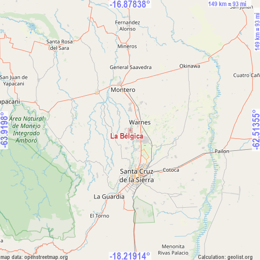
La Bélgica GPS coordinates[2]
17° 33' 0" South, 63° 13' 0.012" West
| Map corner | latitude | longitude |
|---|---|---|
| Upper-left | -16.87838°, | -63.9198° |
| Center: | -17.55°, | -63.21667° |
| Lower-right: | -18.21914°, | -62.51355° |
| Map W x H: | 149.1×149.1 km | = 92.6×92.6mi |
| max Lat: | -9.71828° ⇑37.3% North |
| La Bélgica: | -17.55° |
| min Lat: | ⇓62.7% South -22.73206° |
| min Long | La Bélgica | max Long |
| -69.14843° | -63.21667° | -57.76667° |
| W 85.7%⇐ | ⇒14.3% E |
Elevation
Elevation of La Bélgica is 353 m = 1158 ft, and this is 1658.3 m = 5441 ft below average elevation for this country.
| Max E: |
4732 m = 15525 ft | 78.3% |
| Avg. | 2011.3 m = 6599 ft | |
| La Bélgica | 353 m = 1158 ft | |
Min E: |
92 m = 302 ft | 21.7% |
See also: Bolivia elevation on elevation.city.
Geographical zone
La Bélgica is located in South Torrid zone (between Equator and Tropic of Capricorn). Distance of this Southern Tropic circle is 654.5 km =406.7 mi to South.| Distance of | km | miles | from La Bélgica |
|---|---|---|---|
| Equator | 1951.4 | 1212.5 | to North |
| Tropic Capricorn | 654.5 | 406.7 | to South |
| Antarctic Circle | 5449.8 | 3386.3 | to South |
| South Pole | 8055.7 | 5005.6 | to South |


Nearby cities:
15 places around La Bélgica: (largest is in red/bold)
• Cotoca
34.5 km =21.4 mi,  149°
149°
• Cotoca
46.2 km =28.7 mi,  118°
118°
• Los Negros
30.7 km =19.1 mi,  228°
228°
• Mineros
48 km =29.8 mi,  358°
358°
• Montero
23.8 km =14.8 mi,  351°
351°
• Paurito
45.5 km =28.3 mi,  144°
144°
• Portachuelo
28.9 km =18 mi,  319°
319°
• Puearto Pailas
44.7 km =27.8 mi,  106°
106°
• Puesto de Pailas
45.5 km =28.3 mi,  104°
104°
• San Julian
44.4 km =27.6 mi,  129°
129°
• San Julian
45.3 km =28.1 mi, 124°
• Santa Cruz de la Sierra
26.5 km =16.5 mi,  171°
171°
• Santa Fe
44 km =27.3 mi, 154°
• Santa Rita
48.4 km =30.1 mi,  196°
196°
• Warnes
6.4 km =4 mi,  54°
54°
Sources, notices
• [Note1] Compared only with cities in Bolivia existing in our database
• [Src1] Map data: © OpenStreetMap contributors (CC-BY-SA)
• [Src2] Other city data from geonames.org with taken over terms of usage.
• [Src3] Geographical zone / Annual Mean Temperature by Robert A. Rohde @ Wikipedia
