Camargo geodata
Camargo (Chuquisaca) is a seat of a fourth-order administrative division; located in Bolivia in America/La_Paz (GMT-4) time zone. With population of 4,715 people, there are 62 cities with bigger population in this country. Compared to other cities in Bolivia, 87% of cities are located further ↑North; 50.9% of cities are located further ←West and 51.6% of cities have lower elevation than Camargo. Note1
Administrative division(s):
- Level 1: Chuquisaca
- Level 2: Provincia Nor Cinti
- Level 3: Camargo
- Level 4: Camargo


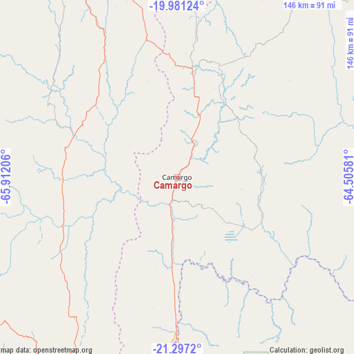
Camargo GPS coordinates[2]
20° 38' 26.304" South, 65° 12' 32.148" West
| Map corner | latitude | longitude |
|---|---|---|
| Upper-left | -19.98124°, | -65.91206° |
| Center: | -20.64064°, | -65.20893° |
| Lower-right: | -21.2972°, | -64.50581° |
| Map W x H: | 146.3×146.3 km | = 90.9×90.9mi |
| max Lat: | -9.71828° ⇑87% North |
| Camargo: | -20.64064° |
| min Lat: | ⇓13% South -22.73206° |
| min Long | Camargo | max Long |
| -69.14843° | -65.20893° | -57.76667° |
| W 50.9%⇐ | ⇒49.1% E |
Elevation
Elevation of Camargo is 2412 m = 7913 ft, and this is 400.7 m = 1315 ft above average elevation for this country.
| Max E: |
4732 m = 15525 ft | 48.4% |
| Camargo | 2412 m 7913 ft | |
| Avg. | 2011.3 m = 6599 ft | |
Min E: |
92 m = 302 ft | 51.6% |
See also: Bolivia elevation on elevation.city.
Geographical zone
Camargo is located in South Torrid zone (between Equator and Tropic of Capricorn). Distance of this Southern Tropic circle is 310.9 km =193.2 mi to South.| Distance of | km | miles | from Camargo |
|---|---|---|---|
| Equator | 2295 | 1426 | to North |
| Tropic Capricorn | 310.9 | 193.2 | to South |
| Antarctic Circle | 5106.2 | 3172.8 | to South |
| South Pole | 7712 | 4792 | to South |


Nearby cities:
15 places around Camargo: (largest is in red/bold)
• Azurduy
102 km =63.4 mi,  54°
54°
• Culpina
34.2 km =21.3 mi,  126°
126°
• Huajlaya
68.7 km =42.7 mi,  86°
86°
• La Cueva
45.7 km =28.4 mi,  135°
135°
• Las Carreras
63.1 km =39.2 mi,  180°
180°
• Las Carreras
68.2 km =42.4 mi,  186°
186°
• Lintaca
19.1 km =11.9 mi,  222°
222°
• Pilaya
58.8 km =36.5 mi, 125°
• Salitre
40.6 km =25.2 mi, 131°
• San Francisco
53.6 km =33.3 mi,  99°
99°
• San Juan
70.2 km =43.6 mi, 187°
• Santa Bárbara
92.7 km =57.6 mi,  250°
250°
• Santa Elena
45.4 km =28.2 mi,  77°
77°
• Tupiza
103.8 km =64.5 mi,  210°
210°
• Villa Charcas
34.9 km =21.7 mi,  105°
105°
Sources, notices
• [Note1] Compared only with cities in Bolivia existing in our database
• [Src1] Map data: © OpenStreetMap contributors (CC-BY-SA)
• [Src2] Other city data from geonames.org with taken over terms of usage.
• [Src3] Geographical zone / Annual Mean Temperature by Robert A. Rohde @ Wikipedia
