Pilaya geodata
Pilaya (Chuquisaca) is a seat of a fourth-order administrative division; located in Bolivia in America/La_Paz (GMT-4) time zone. In our database, there are 117 cities with bigger population. Compared to other cities in Bolivia, 93.2% of cities are located further ↑North; 61.5% of cities are located further ←West and 59.6% of cities have higher elevation than Pilaya. Note1
Administrative division(s):
- Level 1: Chuquisaca
- Level 2: Provincia Sud Cinti
- Level 3: Culpina
- Level 4: Pilaya


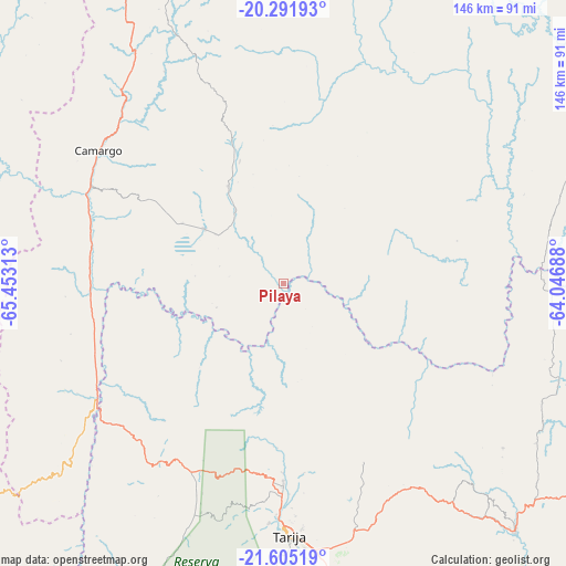
Pilaya GPS coordinates[2]
20° 57' 0" South, 64° 45' 0" West
| Map corner | latitude | longitude |
|---|---|---|
| Upper-left | -20.29193°, | -65.45313° |
| Center: | -20.95°, | -64.75° |
| Lower-right: | -21.60519°, | -64.04688° |
| Map W x H: | 146×146 km | = 90.7×90.7mi |
| max Lat: | -9.71828° ⇑93.2% North |
| Pilaya: | -20.95° |
| min Lat: | ⇓6.8% South -22.73206° |
| min Long | Pilaya | max Long |
| -69.14843° | -64.75° | -57.76667° |
| W 61.5%⇐ | ⇒38.5% E |
Elevation
Elevation of Pilaya is 1614 m = 5295 ft, and this is 397.3 m = 1303 ft below average elevation for this country.
| Max E: |
4732 m = 15525 ft | 59.6% |
| Avg. | 2011.3 m = 6599 ft | |
| Pilaya | 1614 m = 5295 ft | |
Min E: |
92 m = 302 ft | 40.4% |
See also: Bolivia elevation on elevation.city.
Geographical zone
Pilaya is located in South Torrid zone (between Equator and Tropic of Capricorn). Distance of this Southern Tropic circle is 276.5 km =171.8 mi to South.| Distance of | km | miles | from Pilaya |
|---|---|---|---|
| Equator | 2329.4 | 1447.4 | to North |
| Tropic Capricorn | 276.5 | 171.8 | to South |
| Antarctic Circle | 5071.8 | 3151.5 | to South |
| South Pole | 7677.6 | 4770.6 | to South |


Nearby cities:
15 places around Pilaya: (largest is in red/bold)
• Camargo
58.8 km =36.5 mi,  305°
305°
• Culpina
24.6 km =15.3 mi,  304°
304°
• Entre Ríos
87.7 km =54.5 mi,  136°
136°
• Huajlaya
44.1 km =27.4 mi,  28°
28°
• La Cueva
15.7 km =9.8 mi,  276°
276°
• Las Carreras
55.7 km =34.6 mi,  238°
238°
• Las Carreras
64.6 km =40.1 mi, 238°
• Lintaca
63.9 km =39.7 mi,  288°
288°
• Rosario del Ingre
97.3 km =60.5 mi,  65°
65°
• Salitre
18.8 km =11.7 mi, 293°
• San Francisco
26.5 km =16.5 mi,  11°
11°
• San Juan
67 km =41.6 mi, 238°
• Santa Elena
44.6 km =27.7 mi,  355°
355°
• Tarija
65.1 km =40.5 mi,  178°
178°
• Villa Charcas
28.9 km =18 mi,  330°
330°
Sources, notices
• [Note1] Compared only with cities in Bolivia existing in our database
• [Src1] Map data: © OpenStreetMap contributors (CC-BY-SA)
• [Src2] Other city data from geonames.org with taken over terms of usage.
• [Src3] Geographical zone / Annual Mean Temperature by Robert A. Rohde @ Wikipedia
