Aiquile geodata
Aiquile (Cochabamba) is a populated place; located in Bolivia in America/La_Paz (GMT-4) time zone. With population of 8,224 people, there are 48 cities with bigger population in this country. Compared to other cities in Bolivia, 57.1% of cities are located further ↑North; 52.2% of cities are located further ←West and 52.2% of cities have higher elevation than Aiquile. Note1


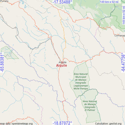
Aiquile GPS coordinates[2]
18° 12' 14.688" South, 65° 10' 50.448" West
| Map corner | latitude | longitude |
|---|---|---|
| Upper-left | -17.53488°, | -65.88381° |
| Center: | -18.20408°, | -65.18068° |
| Lower-right: | -18.87072°, | -64.47756° |
| Map W x H: | 148.5×148.5 km | = 92.3×92.3mi |
| max Lat: | -9.71828° ⇑57.1% North |
| Aiquile: | -18.20408° |
| min Lat: | ⇓42.9% South -22.73206° |
| min Long | Aiquile | max Long |
| -69.14843° | -65.18068° | -57.76667° |
| W 52.2%⇐ | ⇒47.8% E |
Elevation
Elevation of Aiquile is 2258 m = 7408 ft, and this is 246.7 m = 809 ft above average elevation for this country.
| Max E: |
4732 m = 15525 ft | 52.2% |
| Aiquile | 2258 m 7408 ft | |
| Avg. | 2011.3 m = 6599 ft | |
Min E: |
92 m = 302 ft | 47.8% |
See also: Bolivia elevation on elevation.city.
Geographical zone
Aiquile is located in South Torrid zone (between Equator and Tropic of Capricorn). Distance of this Southern Tropic circle is 581.8 km =361.5 mi to South.| Distance of | km | miles | from Aiquile |
|---|---|---|---|
| Equator | 2024.1 | 1257.7 | to North |
| Tropic Capricorn | 581.8 | 361.5 | to South |
| Antarctic Circle | 5377.1 | 3341.2 | to South |
| South Pole | 7983 | 4960.4 | to South |


Nearby cities:
15 places around Aiquile: (largest is in red/bold)
• Arani
94.2 km =58.5 mi,  318°
318°
• Cañada Hornillos
57.8 km =35.9 mi,  4°
4°
• Chaunaca
95.2 km =59.2 mi,  198°
198°
• Chuqui Chuqui
69.2 km =43 mi,  169°
169°
• Comarapa
75.8 km =47.1 mi,  64°
64°
• Huata
90.6 km =56.3 mi,  184°
184°
• Mizque
33.8 km =21 mi,  330°
330°
• Mojocoya
85.9 km =53.4 mi,  136°
136°
• Mojotoro
80.1 km =49.8 mi, 171°
• Piocera
65 km =40.4 mi, 200°
• Pocpo
72.7 km =45.2 mi, 195°
• Potolo
96.4 km =59.9 mi, 202°
• Presto
84.6 km =52.6 mi,  162°
162°
• Sucre
92.6 km =57.5 mi,  185°
185°
• Totora
53.1 km =33 mi,  358°
358°
Sources, notices
• [Note1] Compared only with cities in Bolivia existing in our database
• [Src1] Map data: © OpenStreetMap contributors (CC-BY-SA)
• [Src2] Other city data from geonames.org with taken over terms of usage.
• [Src3] Geographical zone / Annual Mean Temperature by Robert A. Rohde @ Wikipedia
