Cañada Hornillos geodata
Cañada Hornillos (Cochabamba) is a populated place; located in Bolivia in America/La_Paz (GMT-4) time zone. With population of 518 people, there are 116 cities with bigger population in this country. Compared to other cities in Bolivia, 57.8% of cities are located further ↓South; 53.4% of cities are located further ←West and 75.2% of cities have lower elevation than Cañada Hornillos. Note1


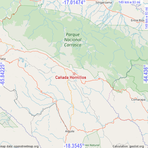
Cañada Hornillos GPS coordinates[2]
17° 41' 9.132" South, 65° 8' 20.832" West
| Map corner | latitude | longitude |
|---|---|---|
| Upper-left | -17.01474°, | -65.84225° |
| Center: | -17.68587°, | -65.13912° |
| Lower-right: | -18.3545°, | -64.436° |
| Map W x H: | 149×149 km | = 92.6×92.6mi |
| max Lat: | -9.71828° ⇑42.2% North |
| Cañada Hornillos: | -17.68587° |
| min Lat: | ⇓57.8% South -22.73206° |
| min Long | Cañada Hornill | max Long |
| -69.14843° | -65.13912° | -57.76667° |
| W 53.4%⇐ | ⇒46.6% E |
Elevation
Elevation of Cañada Hornillos is 3123 m = 10246 ft, and this is 1111.7 m = 3647 ft above average elevation for this country.
| Max E: |
4732 m = 15525 ft | 24.8% |
| Cañada Hornillos | 3123 m 10246 ft | |
| Avg. | 2011.3 m = 6599 ft | |
Min E: |
92 m = 302 ft | 75.2% |
See also: Bolivia elevation on elevation.city.
Geographical zone
Cañada Hornillos is located in South Torrid zone (between Equator and Tropic of Capricorn). Distance of this Southern Tropic circle is 639.4 km =397.3 mi to South.| Distance of | km | miles | from Cañada Hornillos |
|---|---|---|---|
| Equator | 1966.5 | 1221.9 | to North |
| Tropic Capricorn | 639.4 | 397.3 | to South |
| Antarctic Circle | 5434.7 | 3377 | to South |
| South Pole | 8040.6 | 4996.2 | to South |


Nearby cities:
15 places around Cañada Hornillos: (largest is in red/bold)
• Aiquile
57.8 km =35.9 mi,  184°
184°
• Arani
68 km =42.3 mi,  281°
281°
• Capinota
118.9 km =73.9 mi,  268°
268°
• Chimoré
76.9 km =47.8 mi,  358°
358°
• Cliza
84.8 km =52.7 mi, 277°
• Cochabamba
112.8 km =70.1 mi,  286°
286°
• Colomi
85.7 km =53.3 mi,  295°
295°
• Comarapa
69.2 km =43 mi,  111°
111°
• Irpa Irpa
119.5 km =74.3 mi, 268°
• Mizque
35.5 km =22.1 mi,  216°
216°
• Punata
75.4 km =46.9 mi, 282°
• Sacaba
100.6 km =62.5 mi, 288°
• Tarata
93.9 km =58.3 mi, 275°
• Tiquipaya
120.5 km =74.9 mi, 288°
• Totora
7.3 km =4.5 mi,  231°
231°
Sources, notices
• [Note1] Compared only with cities in Bolivia existing in our database
• [Src1] Map data: © OpenStreetMap contributors (CC-BY-SA)
• [Src2] Other city data from geonames.org with taken over terms of usage.
• [Src3] Geographical zone / Annual Mean Temperature by Robert A. Rohde @ Wikipedia
