Comarapa geodata
Comarapa (Santa Cruz) is a populated place; located in Bolivia in America/La_Paz (GMT-4) time zone. With population of 4,445 people, there are 64 cities with bigger population in this country. Compared to other cities in Bolivia, 50.9% of cities are located further ↑North; 65.8% of cities are located further ←West and 57.8% of cities have higher elevation than Comarapa. Note1


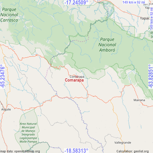
Comarapa GPS coordinates[2]
17° 54' 55.332" South, 64° 31' 53.868" West
| Map corner | latitude | longitude |
|---|---|---|
| Upper-left | -17.24509°, | -65.23476° |
| Center: | -17.91537°, | -64.53163° |
| Lower-right: | -18.58313°, | -63.82851° |
| Map W x H: | 148.8×148.8 km | = 92.5×92.5mi |
| max Lat: | -9.71828° ⇑50.9% North |
| Comarapa: | -17.91537° |
| min Lat: | ⇓49.1% South -22.73206° |
| min Long | Comarapa | max Long |
| -69.14843° | -64.53163° | -57.76667° |
| W 65.8%⇐ | ⇒34.2% E |
Elevation
Elevation of Comarapa is 1818 m = 5965 ft, and this is 193.3 m = 634 ft below average elevation for this country.
| Max E: |
4732 m = 15525 ft | 57.8% |
| Avg. | 2011.3 m = 6599 ft | |
| Comarapa | 1818 m = 5965 ft | |
Min E: |
92 m = 302 ft | 42.2% |
See also: Bolivia elevation on elevation.city.
Geographical zone
Comarapa is located in South Torrid zone (between Equator and Tropic of Capricorn). Distance of this Southern Tropic circle is 613.9 km =381.5 mi to South.| Distance of | km | miles | from Comarapa |
|---|---|---|---|
| Equator | 1992 | 1237.8 | to North |
| Tropic Capricorn | 613.9 | 381.5 | to South |
| Antarctic Circle | 5409.2 | 3361.1 | to South |
| South Pole | 8015.1 | 4980.4 | to South |


Nearby cities:
15 places around Comarapa: (largest is in red/bold)
• Aiquile
75.8 km =47.1 mi,  244°
244°
• Buena Vista
104.4 km =64.9 mi,  60°
60°
• Cañada Hornillos
69.2 km =43 mi,  291°
291°
• Chuqui Chuqui
115 km =71.5 mi,  209°
209°
• Jorochito
117.7 km =73.1 mi,  97°
97°
• Los Negros
118 km =73.3 mi,  80°
80°
• Mairana
64.6 km =40.1 mi,  110°
110°
• Mizque
85.6 km =53.2 mi,  268°
268°
• Mojocoya
94.8 km =58.9 mi,  185°
185°
• Samaipata
75.3 km =46.8 mi, 112°
• San Carlos
100.7 km =62.6 mi, 55°
• San Juan del Surutú
100.3 km =62.3 mi, 61°
• Totora
73.1 km =45.4 mi, 286°
• Vallegrande
78 km =48.5 mi,  144°
144°
• Villa Yapacaní
93.6 km =58.2 mi,  52°
52°
Sources, notices
• [Note1] Compared only with cities in Bolivia existing in our database
• [Src1] Map data: © OpenStreetMap contributors (CC-BY-SA)
• [Src2] Other city data from geonames.org with taken over terms of usage.
• [Src3] Geographical zone / Annual Mean Temperature by Robert A. Rohde @ Wikipedia
