Conde geodata
Conde (Paraíba) is a populated place; located in Brazil in America/Fortaleza (GMT-3) time zone. With population of 15,859 people, there are 1166 cities with bigger population in this country. Compared to other cities in Brazil, 78.9% of cities are located further ↓South; 99.5% of cities are located further ←West and 70.9% of cities have higher elevation than Conde. Note1


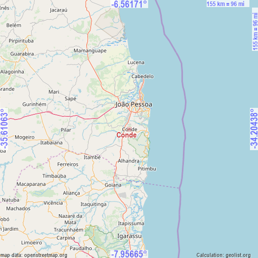
Conde GPS coordinates[2]
7° 15' 34.992" South, 34° 54' 27" West
| Map corner | latitude | longitude |
|---|---|---|
| Upper-left | -6.56171°, | -35.61063° |
| Center: | -7.25972°, | -34.9075° |
| Lower-right: | -7.95665°, | -34.20438° |
| Map W x H: | 155.1×155.1 km | = 96.4×96.4mi |
| max Lat: | 2.81972° ⇑21.1% North |
| Conde: | -7.25972° |
| min Lat: | ⇓78.9% South -33.69111° |
| min Long | Conde | max Long |
| -72.89583° | -34.9075° | -32.41083° |
| W 99.5%⇐ | ⇒0.5% E |
Elevation
Elevation of Conde is 116 m = 381 ft, and this is 264.9 m = 869 ft below average elevation for this country.
| Max E: |
1603 m = 5259 ft | 70.9% |
| Avg. | 380.9 m = 1250 ft | |
| Conde | 116 m = 381 ft | |
Min E: |
0 m = 0 ft | 29.1% |
See also: Brazil elevation on elevation.city.
Geographical zone
Conde is located in South Torrid zone (between Equator and Tropic of Capricorn). Distance of Equator is 807.2 km =501.6 mi to North.| Distance of | km | miles | from Conde |
|---|---|---|---|
| Equator | 807.2 | 501.6 | to North |
| Tropic Capricorn | 1798.7 | 1117.7 | to South |
| Antarctic Circle | 6594 | 4097.3 | to South |
| South Pole | 9199.9 | 5716.6 | to South |


Nearby cities:
15 places around Conde: (largest is in red/bold)
• Alhandra
19.9 km =12.4 mi,  182°
182°
• Bayeux
15.2 km =9.4 mi,  349°
349°
• Caaporã
28.4 km =17.6 mi, 180°
• Cabedelo
32 km =19.9 mi,  14°
14°
• Ciceroândia
8.4 km =5.2 mi,  276°
276°
• Condado
42.3 km =26.3 mi,  211°
211°
• Cruz do Espírito Santo
23.8 km =14.8 mi,  304°
304°
• Goiana
35.1 km =21.8 mi,  197°
197°
• Itabaiana
47.5 km =29.5 mi,  260°
260°
• João Pessoa
16.8 km =10.4 mi,  16°
16°
• Juripiranga
38.6 km =24 mi,  250°
250°
• Pedras de Fogo
27.9 km =17.3 mi,  235°
235°
• Pilar
38.9 km =24.2 mi,  268°
268°
• Pitimbu
25.9 km =16.1 mi,  155°
155°
• Santa Rita
18 km =11.2 mi,  334°
334°
Sources, notices
• [Note1] Compared only with cities in Brazil existing in our database
• [Src1] Map data: © OpenStreetMap contributors (CC-BY-SA)
• [Src2] Other city data from geonames.org with taken over terms of usage.
• [Src3] Geographical zone / Annual Mean Temperature by Robert A. Rohde @ Wikipedia
