João Pessoa geodata
João Pessoa (Paraíba) is a seat of a first-order administrative division; located in Brazil in America/Fortaleza (GMT-3) time zone. With population of 650,883 people, there are 25 cities with bigger population in this country. Compared to other cities in Brazil, 79.9% of cities are located further ↓South; 99.8% of cities are located further ←West and 80.2% of cities have higher elevation than João Pessoa. Note1


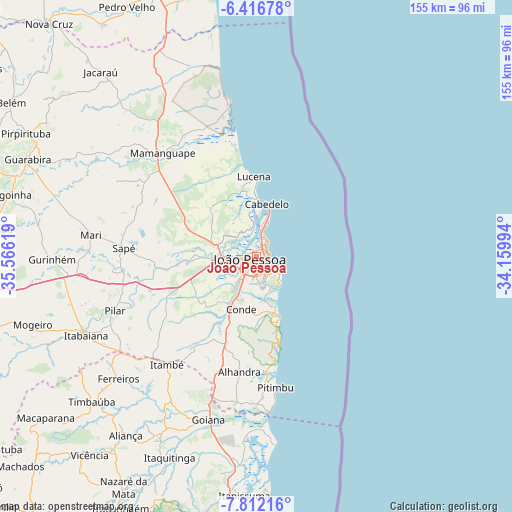
João Pessoa GPS coordinates[2]
7° 6' 54" South, 34° 51' 47.016" West
| Map corner | latitude | longitude |
|---|---|---|
| Upper-left | -6.41678°, | -35.56619° |
| Center: | -7.115°, | -34.86306° |
| Lower-right: | -7.81216°, | -34.15994° |
| Map W x H: | 155.2×155.2 km | = 96.4×96.4mi |
| max Lat: | 2.81972° ⇑20.1% North |
| João Pessoa: | -7.115° |
| min Lat: | ⇓79.9% South -33.69111° |
| min Long | João Pessoa | max Long |
| -72.89583° | -34.86306° | -32.41083° |
| W 99.8%⇐ | ⇒0.2% E |
Elevation
Elevation of João Pessoa is 45 m = 148 ft, and this is 335.9 m = 1102 ft below average elevation for this country.
| Max E: |
1603 m = 5259 ft | 80.2% |
| Avg. | 380.9 m = 1250 ft | |
| João Pessoa | 45 m = 148 ft | |
Min E: |
0 m = 0 ft | 19.8% |
See also: João Pessoa elevation on elevation.city.
Geographical zone
João Pessoa is located in South Torrid zone (between Equator and Tropic of Capricorn). Distance of Equator is 791.1 km =491.6 mi to North.| Distance of | km | miles | from João Pessoa |
|---|---|---|---|
| Equator | 791.1 | 491.6 | to North |
| Tropic Capricorn | 1814.8 | 1127.7 | to South |
| Antarctic Circle | 6610.1 | 4107.3 | to South |
| South Pole | 9215.9 | 5726.5 | to South |


Nearby cities:
15 places around João Pessoa: (largest is in red/bold)
• Alhandra
36.4 km =22.6 mi,  188°
188°
• Bayeux
7.7 km =4.8 mi,  261°
261°
• Caaporã
44.8 km =27.8 mi, 186°
• Cabedelo
15.2 km =9.4 mi,  12°
12°
• Ciceroândia
20.1 km =12.5 mi,  221°
221°
• Conde
16.8 km =10.4 mi,  196°
196°
• Cruz do Espírito Santo
24.8 km =15.4 mi, 263°
• Juripiranga
50.4 km =31.3 mi,  235°
235°
• Mamanguape
42.3 km =26.3 mi,  316°
316°
• Mari
50.7 km =31.5 mi,  276°
276°
• Pedras de Fogo
42.4 km =26.3 mi, 221°
• Pilar
46.9 km =29.1 mi,  248°
248°
• Pitimbu
40 km =24.9 mi,  171°
171°
• Rio Tinto
42.2 km =26.2 mi,  325°
325°
• Santa Rita
12.7 km =7.9 mi,  270°
270°
Sources, notices
• [Note1] Compared only with cities in Brazil existing in our database
• [Src1] Map data: © OpenStreetMap contributors (CC-BY-SA)
• [Src2] Other city data from geonames.org with taken over terms of usage.
• [Src3] Geographical zone / Annual Mean Temperature by Robert A. Rohde @ Wikipedia
