Alhandra geodata
Alhandra (Paraíba) is a populated place; located in Brazil in America/Fortaleza (GMT-3) time zone. With population of 10,788 people, there are 1582 cities with bigger population in this country. Compared to other cities in Brazil, 78% of cities are located further ↓South; 99.4% of cities are located further ←West and 81.8% of cities have higher elevation than Alhandra. Note1


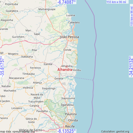
Alhandra GPS coordinates[2]
7° 26' 18.996" South, 34° 54' 51.984" West
| Map corner | latitude | longitude |
|---|---|---|
| Upper-left | -6.74087°, | -35.61757° |
| Center: | -7.43861°, | -34.91444° |
| Lower-right: | -8.13525°, | -34.21132° |
| Map W x H: | 155×155 km | = 96.3×96.3mi |
| max Lat: | 2.81972° ⇑22% North |
| Alhandra: | -7.43861° |
| min Lat: | ⇓78% South -33.69111° |
| min Long | Alhandra | max Long |
| -72.89583° | -34.91444° | -32.41083° |
| W 99.4%⇐ | ⇒0.59999999999999% E |
Elevation
Elevation of Alhandra is 39 m = 128 ft, and this is 341.9 m = 1122 ft below average elevation for this country.
| Max E: |
1603 m = 5259 ft | 81.8% |
| Avg. | 380.9 m = 1250 ft | |
| Alhandra | 39 m = 128 ft | |
Min E: |
0 m = 0 ft | 18.2% |
See also: Brazil elevation on elevation.city.
Geographical zone
Alhandra is located in South Torrid zone (between Equator and Tropic of Capricorn). Distance of Equator is 827.1 km =513.9 mi to North.| Distance of | km | miles | from Alhandra |
|---|---|---|---|
| Equator | 827.1 | 513.9 | to North |
| Tropic Capricorn | 1778.8 | 1105.3 | to South |
| Antarctic Circle | 6574.1 | 4085 | to South |
| South Pole | 9180 | 5704.2 | to South |


Nearby cities:
15 places around Alhandra: (largest is in red/bold)
• Bayeux
34.9 km =21.7 mi,  356°
356°
• Caaporã
8.6 km =5.3 mi,  175°
175°
• Ciceroândia
22.2 km =13.8 mi,  339°
339°
• Condado
26.7 km =16.6 mi,  232°
232°
• Conde
19.9 km =12.4 mi,  2°
2°
• Cruz do Espírito Santo
38.2 km =23.7 mi,  330°
330°
• Goiana
16.7 km =10.4 mi,  215°
215°
• Itamaracá
35.7 km =22.2 mi,  164°
164°
• Itapissuma
37.6 km =23.4 mi, 176°
• Itaquitinga
32.8 km =20.4 mi, 219°
• João Pessoa
36.4 km =22.6 mi,  8°
8°
• Juripiranga
36.4 km =22.6 mi,  281°
281°
• Pedras de Fogo
22.6 km =14 mi, 280°
• Pitimbu
12.2 km =7.6 mi,  106°
106°
• Santa Rita
36.8 km =22.9 mi,  349°
349°
Sources, notices
• [Note1] Compared only with cities in Brazil existing in our database
• [Src1] Map data: © OpenStreetMap contributors (CC-BY-SA)
• [Src2] Other city data from geonames.org with taken over terms of usage.
• [Src3] Geographical zone / Annual Mean Temperature by Robert A. Rohde @ Wikipedia
