Caaporã geodata
Caaporã (Paraíba) is a populated place; located in Brazil in America/Fortaleza (GMT-3) time zone. With population of 13,769 people, there are 1311 cities with bigger population in this country. Compared to other cities in Brazil, 77.6% of cities are located further ↓South; 99.4% of cities are located further ←West and 84.4% of cities have higher elevation than Caaporã. Note1


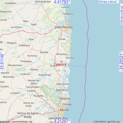
Caaporã GPS coordinates[2]
7° 30' 56.016" South, 34° 54' 29.988" West
| Map corner | latitude | longitude |
|---|---|---|
| Upper-left | -6.81793°, | -35.61146° |
| Center: | -7.51556°, | -34.90833° |
| Lower-right: | -8.21207°, | -34.20521° |
| Map W x H: | 155×155 km | = 96.3×96.3mi |
| max Lat: | 2.81972° ⇑22.4% North |
| Caaporã: | -7.51556° |
| min Lat: | ⇓77.6% South -33.69111° |
| min Long | Caaporã | max Long |
| -72.89583° | -34.90833° | -32.41083° |
| W 99.4%⇐ | ⇒0.59999999999999% E |
Elevation
Elevation of Caaporã is 32 m = 105 ft, and this is 348.9 m = 1145 ft below average elevation for this country.
| Max E: |
1603 m = 5259 ft | 84.4% |
| Avg. | 380.9 m = 1250 ft | |
| Caaporã | 32 m = 105 ft | |
Min E: |
0 m = 0 ft | 15.6% |
See also: Brazil elevation on elevation.city.
Geographical zone
Caaporã is located in South Torrid zone (between Equator and Tropic of Capricorn). Distance of Equator is 835.7 km =519.3 mi to North.| Distance of | km | miles | from Caaporã |
|---|---|---|---|
| Equator | 835.7 | 519.3 | to North |
| Tropic Capricorn | 1770.3 | 1100 | to South |
| Antarctic Circle | 6565.5 | 4079.6 | to South |
| South Pole | 9171.4 | 5698.8 | to South |


Nearby cities:
15 places around Caaporã: (largest is in red/bold)
• Alhandra
8.6 km =5.3 mi,  355°
355°
• Araçoiaba
36.6 km =22.7 mi,  213°
213°
• Bayeux
43.5 km =27 mi, 356°
• Ciceroândia
30.5 km =19 mi,  344°
344°
• Condado
23.1 km =14.4 mi,  250°
250°
• Conde
28.4 km =17.6 mi,  0°
0°
• Goiana
11.5 km =7.1 mi,  244°
244°
• Igarassu
35.4 km =22 mi,  179°
179°
• Itamaracá
27.4 km =17 mi,  160°
160°
• Itapissuma
29.1 km =18.1 mi, 176°
• Itaquitinga
27.2 km =16.9 mi,  231°
231°
• Juripiranga
39.6 km =24.6 mi,  293°
293°
• Nazaré da Mata
43.3 km =26.9 mi, 234°
• Pedras de Fogo
26.2 km =16.3 mi,  298°
298°
• Pitimbu
12.1 km =7.5 mi,  65°
65°
Sources, notices
• [Note1] Compared only with cities in Brazil existing in our database
• [Src1] Map data: © OpenStreetMap contributors (CC-BY-SA)
• [Src2] Other city data from geonames.org with taken over terms of usage.
• [Src3] Geographical zone / Annual Mean Temperature by Robert A. Rohde @ Wikipedia
