Piancó geodata
Piancó (Paraíba) is a populated place; located in Brazil in America/Fortaleza (GMT-3) time zone. With population of 10,481 people, there are 1600 cities with bigger population in this country. Compared to other cities in Brazil, 79.5% of cities are located further ↓South; 84.8% of cities are located further ←West and 55% of cities have higher elevation than Piancó. Note1


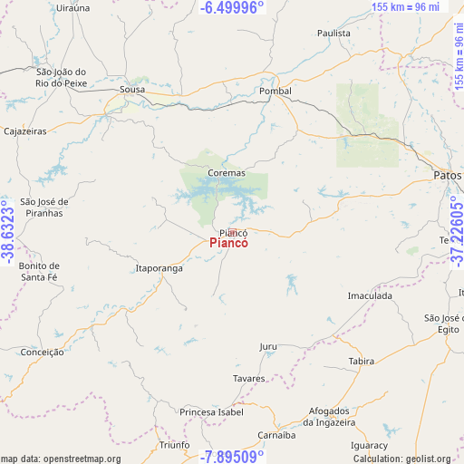
Piancó GPS coordinates[2]
7° 11' 53.016" South, 37° 55' 45.012" West
| Map corner | latitude | longitude |
|---|---|---|
| Upper-left | -6.49996°, | -38.6323° |
| Center: | -7.19806°, | -37.92917° |
| Lower-right: | -7.89509°, | -37.22605° |
| Map W x H: | 155.1×155.1 km | = 96.4×96.4mi |
| max Lat: | 2.81972° ⇑20.5% North |
| Piancó: | -7.19806° |
| min Lat: | ⇓79.5% South -33.69111° |
| min Long | Piancó | max Long |
| -72.89583° | -37.92917° | -32.41083° |
| W 84.8%⇐ | ⇒15.2% E |
Elevation
Elevation of Piancó is 268 m = 879 ft, and this is 112.9 m = 370 ft below average elevation for this country.
| Max E: |
1603 m = 5259 ft | 55% |
| Avg. | 380.9 m = 1250 ft | |
| Piancó | 268 m = 879 ft | |
Min E: |
0 m = 0 ft | 45% |
See also: Brazil elevation on elevation.city.
Geographical zone
Piancó is located in South Torrid zone (between Equator and Tropic of Capricorn). Distance of Equator is 800.3 km =497.3 mi to North.| Distance of | km | miles | from Piancó |
|---|---|---|---|
| Equator | 800.3 | 497.3 | to North |
| Tropic Capricorn | 1805.6 | 1121.9 | to South |
| Antarctic Circle | 6600.8 | 4101.5 | to South |
| South Pole | 9206.7 | 5720.8 | to South |


Nearby cities:
15 places around Piancó: (largest is in red/bold)
• Afogados da Ingazeira
69.3 km =43.1 mi,  152°
152°
• Coremas
20.5 km =12.7 mi,  354°
354°
• Imaculada
51 km =31.7 mi,  114°
114°
• Itaporanga
27.1 km =16.8 mi,  244°
244°
• Juru
39.6 km =24.6 mi,  162°
162°
• Juàzeirinho
44.5 km =27.7 mi,  342°
342°
• Manaíra
61.7 km =38.3 mi,  203°
203°
• Patos
74.2 km =46.1 mi,  74°
74°
• Pombal
49.6 km =30.8 mi,  16°
16°
• Princesa Isabel
60.3 km =37.5 mi,  186°
186°
• Sousa
58.9 km =36.6 mi,  325°
325°
• São José de Piranhas
63.8 km =39.6 mi,  277°
277°
• Tabira
61.3 km =38.1 mi,  135°
135°
• Tavares
49 km =30.4 mi,  173°
173°
• Teixeira
74.5 km =46.3 mi,  92°
92°
Sources, notices
• [Note1] Compared only with cities in Brazil existing in our database
• [Src1] Map data: © OpenStreetMap contributors (CC-BY-SA)
• [Src2] Other city data from geonames.org with taken over terms of usage.
• [Src3] Geographical zone / Annual Mean Temperature by Robert A. Rohde @ Wikipedia
