Itaporanga geodata
Itaporanga (Paraíba) is a populated place; located in Brazil in America/Fortaleza (GMT-3) time zone. With population of 15,890 people, there are 1163 cities with bigger population in this country. Compared to other cities in Brazil, 78.6% of cities are located further ↓South; 83.9% of cities are located further ←West and 53.4% of cities have higher elevation than Itaporanga. Note1


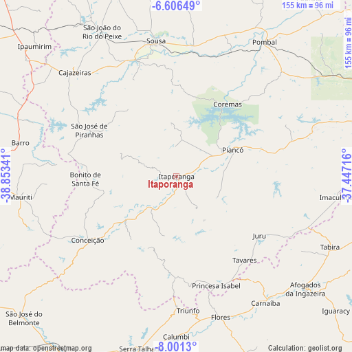
Itaporanga GPS coordinates[2]
7° 18' 15.984" South, 38° 9' 1.008" West
| Map corner | latitude | longitude |
|---|---|---|
| Upper-left | -6.60649°, | -38.85341° |
| Center: | -7.30444°, | -38.15028° |
| Lower-right: | -8.0013°, | -37.44716° |
| Map W x H: | 155.1×155.1 km | = 96.4×96.4mi |
| max Lat: | 2.81972° ⇑21.4% North |
| Itaporanga: | -7.30444° |
| min Lat: | ⇓78.6% South -33.69111° |
| min Long | Itaporanga | max Long |
| -72.89583° | -38.15028° | -32.41083° |
| W 83.9%⇐ | ⇒16.1% E |
Elevation
Elevation of Itaporanga is 295 m = 968 ft, and this is 85.9 m = 282 ft below average elevation for this country.
| Max E: |
1603 m = 5259 ft | 53.4% |
| Avg. | 380.9 m = 1250 ft | |
| Itaporanga | 295 m = 968 ft | |
Min E: |
0 m = 0 ft | 46.6% |
See also: Brazil elevation on elevation.city.
Geographical zone
Itaporanga is located in South Torrid zone (between Equator and Tropic of Capricorn). Distance of Equator is 812.2 km =504.7 mi to North.| Distance of | km | miles | from Itaporanga |
|---|---|---|---|
| Equator | 812.2 | 504.7 | to North |
| Tropic Capricorn | 1793.7 | 1114.6 | to South |
| Antarctic Circle | 6589 | 4094.2 | to South |
| South Pole | 9194.9 | 5713.4 | to South |


Nearby cities:
15 places around Itaporanga: (largest is in red/bold)
• Afogados da Ingazeira
75.1 km =46.7 mi,  131°
131°
• Cajazeiras
64.2 km =39.9 mi,  315°
315°
• Coremas
39.4 km =24.5 mi,  34°
34°
• Flores
65.6 km =40.8 mi,  162°
162°
• Imaculada
71.3 km =44.3 mi,  97°
97°
• Juru
44.8 km =27.8 mi, 125°
• Juàzeirinho
55.4 km =34.4 mi,  11°
11°
• Manaíra
44.7 km =27.8 mi,  180°
180°
• Piancó
27.1 km =16.8 mi,  64°
64°
• Pombal
70.8 km =44 mi, 32°
• Princesa Isabel
51.1 km =31.8 mi, 160°
• Sousa
61.2 km =38 mi,  351°
351°
• São José de Piranhas
43.8 km =27.2 mi,  297°
297°
• Tabira
74.5 km =46.3 mi,  115°
115°
• Tavares
47.5 km =29.5 mi,  140°
140°
Sources, notices
• [Note1] Compared only with cities in Brazil existing in our database
• [Src1] Map data: © OpenStreetMap contributors (CC-BY-SA)
• [Src2] Other city data from geonames.org with taken over terms of usage.
• [Src3] Geographical zone / Annual Mean Temperature by Robert A. Rohde @ Wikipedia
