Icó geodata
Icó (Ceará) is a populated place; located in Brazil in America/Fortaleza (GMT-3) time zone. With population of 28,323 people, there are 698 cities with bigger population in this country. Compared to other cities in Brazil, 83.5% of cities are located further ↓South; 81.1% of cities are located further ←West and 66.4% of cities have higher elevation than Icó. Note1


Icó GPS coordinates[2]
6° 24' 3.996" South, 38° 51' 43.992" West
| Map corner | latitude | longitude |
|---|---|---|
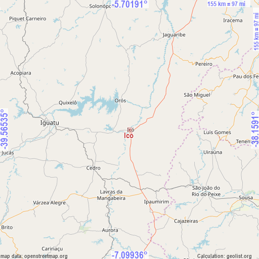
| Upper-left | -5.70191°, | -39.56535° |
| Center: | -6.40111°, | -38.86222° |
| Lower-right: | -7.09936°, | -38.1591° |
| Map W x H: | 155.4×155.4 km | = 96.6×96.6mi |
| max Lat: | 2.81972° ⇑16.5% North |
| Icó: | -6.40111° |
| min Lat: | ⇓83.5% South -33.69111° |
| min Long | Icó | max Long |
| -72.89583° | -38.86222° | -32.41083° |
| W 81.1%⇐ | ⇒18.9% E |
Elevation
Elevation of Icó is 156 m = 512 ft, and this is 224.9 m = 738 ft below average elevation for this country.
| Max E: |
1603 m = 5259 ft | 66.4% |
| Avg. | 380.9 m = 1250 ft | |
| Icó | 156 m = 512 ft | |
Min E: |
0 m = 0 ft | 33.6% |
See also: Brazil elevation on elevation.city.
Geographical zone
Icó is located in South Torrid zone (between Equator and Tropic of Capricorn). Distance of Equator is 711.7 km =442.2 mi to North.| Distance of | km | miles | from Icó |
|---|---|---|---|
| Equator | 711.7 | 442.2 | to North |
| Tropic Capricorn | 1894.2 | 1177 | to South |
| Antarctic Circle | 6689.4 | 4156.6 | to South |
| South Pole | 9295.3 | 5775.8 | to South |


Nearby cities:
15 places around Icó: (largest is in red/bold)
• Acopiara
73.6 km =45.7 mi,  297°
297°
• Aurora
61.3 km =38.1 mi,  190°
190°
• Barro
35.1 km =21.8 mi,  180°
180°
• Cajazeiras
64.1 km =39.8 mi,  148°
148°
• Caririaçu
85.1 km =52.9 mi,  213°
213°
• Cedro
31.8 km =19.8 mi,  224°
224°
• Iguatu
48.4 km =30.1 mi,  275°
275°
• Jaguaribe
62.7 km =39 mi,  25°
25°
• Jucás
74.8 km =46.5 mi,  259°
259°
• Lavras da Mangabeira
40.8 km =25.4 mi,  196°
196°
• Orós
18.3 km =11.4 mi,  341°
341°
• Serra Branca
67.4 km =41.9 mi,  102°
102°
• Sousa
80.6 km =50.1 mi,  119°
119°
• Triunfo
34.3 km =21.3 mi, 122°
• Uiraúna
51.4 km =31.9 mi, 104°
Sources, notices
• [Note1] Compared only with cities in Brazil existing in our database
• [Src1] Map data: © OpenStreetMap contributors (CC-BY-SA)
• [Src2] Other city data from geonames.org with taken over terms of usage.
• [Src3] Geographical zone / Annual Mean Temperature by Robert A. Rohde @ Wikipedia
