Jatobá geodata
Jatobá (Pernambuco) is a populated place; located in Brazil in America/Recife (GMT-3) time zone. With population of 20,575 people, there are 919 cities with bigger population in this country. Compared to other cities in Brazil, 70.5% of cities are located further ↓South; 83.5% of cities are located further ←West and 53.9% of cities have higher elevation than Jatobá. Note1


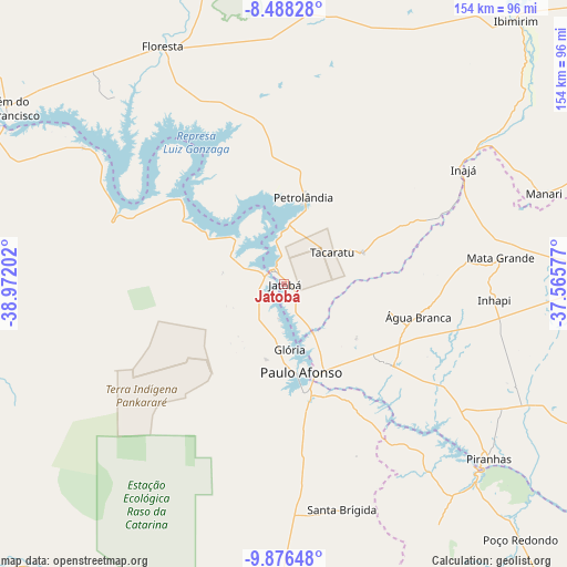
Jatobá GPS coordinates[2]
9° 10' 59.016" South, 38° 16' 8.004" West
| Map corner | latitude | longitude |
|---|---|---|
| Upper-left | -8.48828°, | -38.97202° |
| Center: | -9.18306°, | -38.26889° |
| Lower-right: | -9.87648°, | -37.56577° |
| Map W x H: | 154.4×154.4 km | = 95.9×95.9mi |
| max Lat: | 2.81972° ⇑29.5% North |
| Jatobá: | -9.18306° |
| min Lat: | ⇓70.5% South -33.69111° |
| min Long | Jatobá | max Long |
| -72.89583° | -38.26889° | -32.41083° |
| W 83.5%⇐ | ⇒16.5% E |
Elevation
Elevation of Jatobá is 286 m = 938 ft, and this is 94.9 m = 311 ft below average elevation for this country.
| Max E: |
1603 m = 5259 ft | 53.9% |
| Avg. | 380.9 m = 1250 ft | |
| Jatobá | 286 m = 938 ft | |
Min E: |
0 m = 0 ft | 46.1% |
See also: Brazil elevation on elevation.city.
Geographical zone
Jatobá is located in South Torrid zone (between Equator and Tropic of Capricorn). Distance of Equator is 1021.1 km =634.5 mi to North.| Distance of | km | miles | from Jatobá |
|---|---|---|---|
| Equator | 1021.1 | 634.5 | to North |
| Tropic Capricorn | 1584.9 | 984.8 | to South |
| Antarctic Circle | 6380.1 | 3964.4 | to South |
| South Pole | 8986 | 5583.6 | to South |


Nearby cities:
15 places around Jatobá: (largest is in red/bold)
• Belém de São Francisco
90.2 km =56 mi,  301°
301°
• Canindé de São Francisco
74.7 km =46.4 mi,  135°
135°
• Carnaíba
85.2 km =52.9 mi,  50°
50°
• Delmiro Gouveia
37.4 km =23.2 mi,  127°
127°
• Floresta
72.6 km =45.1 mi,  333°
333°
• Ibimirim
95.6 km =59.4 mi,  41°
41°
• Inhapi
57.3 km =35.6 mi,  94°
94°
• Itaíba
96.5 km =60 mi,  74°
74°
• Jeremoabo
101.9 km =63.3 mi,  193°
193°
• Mata Grande
59.4 km =36.9 mi,  82°
82°
• Paulo Afonso
25.5 km =15.8 mi,  166°
166°
• Poço das Trincheiras
108.9 km =67.7 mi,  97°
97°
• Pão de Açúcar
110.8 km =68.8 mi,  124°
124°
• São José da Tapera
106 km =65.9 mi,  113°
113°
• Água Branca
37.5 km =23.3 mi, 103°
Sources, notices
• [Note1] Compared only with cities in Brazil existing in our database
• [Src1] Map data: © OpenStreetMap contributors (CC-BY-SA)
• [Src2] Other city data from geonames.org with taken over terms of usage.
• [Src3] Geographical zone / Annual Mean Temperature by Robert A. Rohde @ Wikipedia
