Floresta geodata
Floresta (Pernambuco) is a populated place; located in Brazil in America/Recife (GMT-3) time zone. With population of 18,100 people, there are 1039 cities with bigger population in this country. Compared to other cities in Brazil, 72.8% of cities are located further ↓South; 82.2% of cities are located further ←West and 52.2% of cities have higher elevation than Floresta. Note1


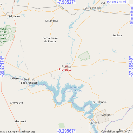
Floresta GPS coordinates[2]
8° 36' 3.996" South, 38° 34' 6.996" West
| Map corner | latitude | longitude |
|---|---|---|
| Upper-left | -7.90527°, | -39.27174° |
| Center: | -8.60111°, | -38.56861° |
| Lower-right: | -9.29567°, | -37.86549° |
| Map W x H: | 154.6×154.6 km | = 96.1×96.1mi |
| max Lat: | 2.81972° ⇑27.2% North |
| Floresta: | -8.60111° |
| min Lat: | ⇓72.8% South -33.69111° |
| min Long | Floresta | max Long |
| -72.89583° | -38.56861° | -32.41083° |
| W 82.2%⇐ | ⇒17.8% E |
Elevation
Elevation of Floresta is 321 m = 1053 ft, and this is 59.9 m = 197 ft below average elevation for this country.
| Max E: |
1603 m = 5259 ft | 52.2% |
| Avg. | 380.9 m = 1250 ft | |
| Floresta | 321 m = 1053 ft | |
Min E: |
0 m = 0 ft | 47.8% |
See also: Brazil elevation on elevation.city.
Geographical zone
Floresta is located in South Torrid zone (between Equator and Tropic of Capricorn). Distance of Equator is 956.4 km =594.3 mi to North.| Distance of | km | miles | from Floresta |
|---|---|---|---|
| Equator | 956.4 | 594.3 | to North |
| Tropic Capricorn | 1649.6 | 1025 | to South |
| Antarctic Circle | 6444.8 | 4004.6 | to South |
| South Pole | 9050.7 | 5623.8 | to South |


Nearby cities:
15 places around Floresta: (largest is in red/bold)
• Belém de São Francisco
46.8 km =29.1 mi,  248°
248°
• Cabrobó
82.1 km =51 mi,  276°
276°
• Carnaíba
99.8 km =62 mi,  96°
96°
• Delmiro Gouveia
107.6 km =66.9 mi,  144°
144°
• Flores
104.5 km =64.9 mi,  38°
38°
• Ibimirim
96.8 km =60.1 mi,  86°
86°
• Inhapi
113.4 km =70.5 mi,  127°
127°
• Jatobá
72.6 km =45.1 mi,  153°
153°
• Manaíra
109.5 km =68 mi,  24°
24°
• Mata Grande
108.4 km =67.4 mi,  121°
121°
• Paulo Afonso
97.6 km =60.6 mi,  156°
156°
• Salgueiro
84.3 km =52.4 mi,  314°
314°
• Serra Talhada
74 km =46 mi, 23°
• São José do Belmonte
84.9 km =52.8 mi,  345°
345°
• Água Branca
101 km =62.8 mi, 136°
Sources, notices
• [Note1] Compared only with cities in Brazil existing in our database
• [Src1] Map data: © OpenStreetMap contributors (CC-BY-SA)
• [Src2] Other city data from geonames.org with taken over terms of usage.
• [Src3] Geographical zone / Annual Mean Temperature by Robert A. Rohde @ Wikipedia
